
The National Weather Service has issued comprehensive Winter Storm Warnings across a substantial portion of California’s majestic Sierra Nevada and the southern reaches of the Cascades, signaling an imminent and impactful weather event. These warnings are set to commence at 2:00 AM Pacific Time on Tuesday and are expected to persist through 5:00 PM Pacific Time on Wednesday, forecasting a significant influx of snow and hazardous conditions for the region. The affected areas encompass some of the state’s most cherished and utilized backcountry destinations, including large sections of Yosemite National Park beyond the valley floor, Kings Canyon and Sequoia National Parks, Lassen Volcanic National Park, and the entirety of the Upper San Joaquin River corridor. Iconic locations such as Tuolumne Meadows, Huntington Lake, Cedar Grove, and Donner Peak are all situated within the zones under the storm warning.
Preceding Conditions and Forecasted Snowfall
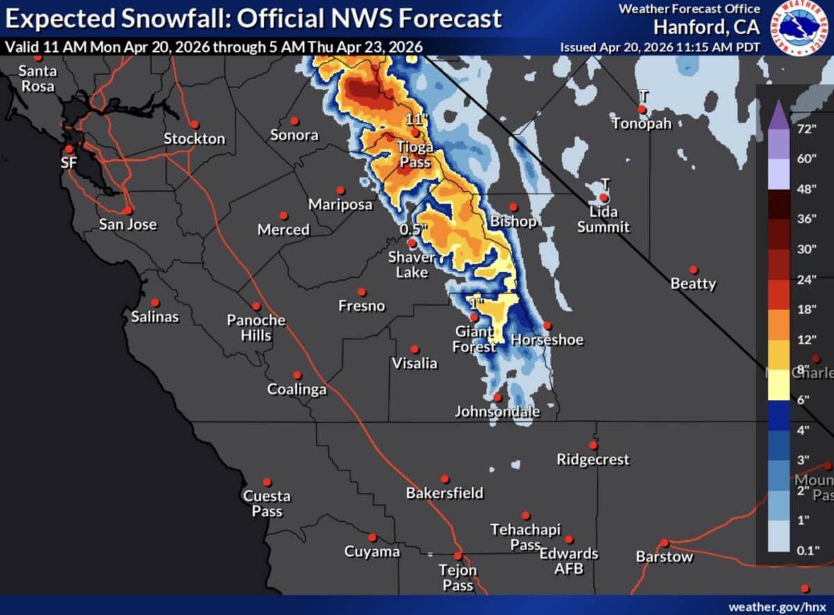
This impending storm arrives as California continues to grapple with its winter precipitation season, with many areas having already experienced variable snowpack levels. The forecast indicates a substantial dump of snow across the higher elevations of the Sierra Nevada and southern Cascades. In the southern Sierra Nevada, elevations exceeding 7,000 feet are anticipated to receive between 3 to 5 inches of snowfall. The highest peaks in this range could potentially accumulate a formidable 12 to 18 inches of new snow. Complementing the snowfall, powerful winds are a significant concern, with gusts potentially reaching up to 75 miles per hour along the Sierra crest. In the northern Sierra, wind gusts are projected to reach up to 50 miles per hour.
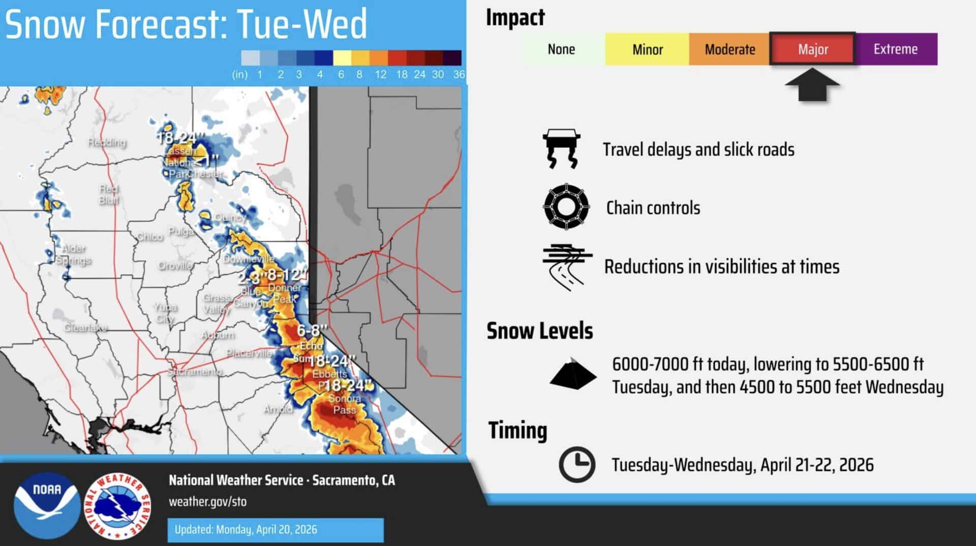
The northern Sierra and southern Cascades regions, situated above 5,000 feet, are forecast to experience similar, if not more intense, conditions. Snow accumulations of 12 to 18 inches are expected at these elevations, with the possibility of up to two feet of snow blanketing the highest peaks. Even areas at lower elevations, down to approximately 4,500 feet, could see some accumulation, potentially up to two inches. The most intense period of snowfall is predicted for Tuesday afternoon and evening, with snowfall rates potentially reaching an astonishing 1 to 2 inches per hour. This intensity raises concerns about rapid accumulation and its impact on accessibility and safety.
Chronology of the Storm Event
The National Weather Service’s advisory indicates that the winter storm will begin to impact the region in the early hours of Tuesday. Initial light to moderate snowfall is expected to develop overnight, intensifying significantly as Tuesday progresses. The peak of the storm, characterized by the heaviest snowfall rates and strongest winds, is projected for Tuesday afternoon and evening. This period is likely to see the most substantial accumulations and the most hazardous travel conditions.
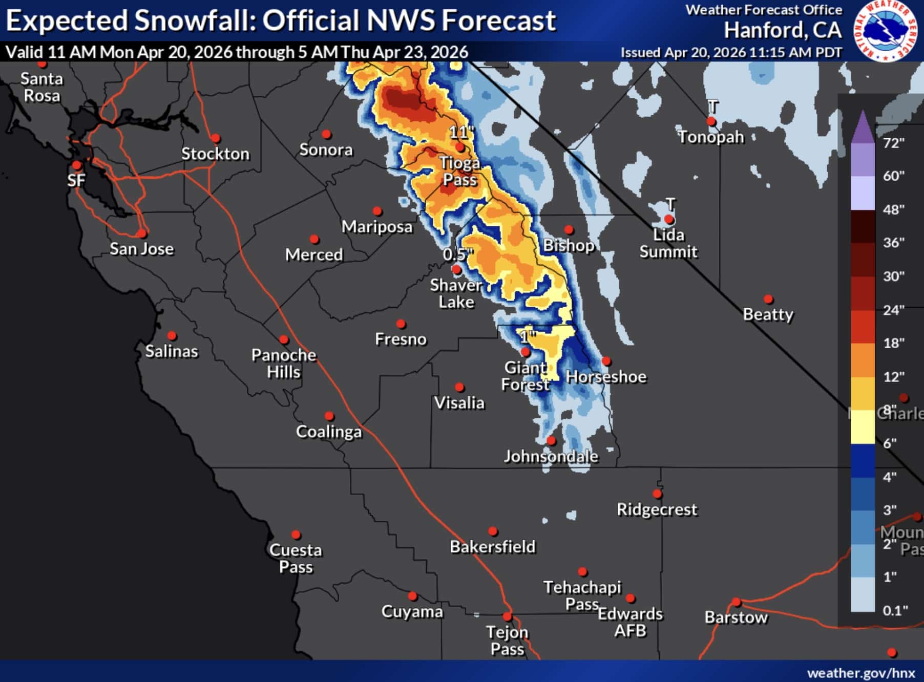
As the storm progresses into Wednesday, snowfall is expected to continue, though perhaps with slightly diminishing intensity in some areas. The Winter Storm Warnings are scheduled to remain in effect until 5:00 PM Pacific Time on Wednesday, suggesting that hazardous conditions will persist throughout the day. This prolonged period of adverse weather necessitates vigilance and preparedness for residents and travelers alike. Post-storm conditions will likely involve significant snow removal efforts and potential lingering hazards such as unstable snowpack and downed trees.
Impact on Travel and Public Safety
Authorities are issuing stern warnings regarding the potential for severely disrupted travel throughout the duration of the storm. The National Weather Service explicitly states that travel could be "very difficult to impossible" across the affected mountain ranges. These hazardous conditions are expected to impact not only recreational travel but also essential commutes for those living in or near mountain communities. The combination of heavy snowfall, reduced visibility, and strong winds creates a dangerous environment for any road travel.
Caltrans, the California Department of Transportation, is urging travelers to exercise extreme caution and to check current road conditions before embarking on any journeys into the mountains. They recommend utilizing their online resource, QuickMap, available at quickmap.dot.ca.gov, which provides real-time updates on road closures, incidents, and traffic conditions. Travelers can also dial 511 for automated road condition information.
In addition to travel advisories, the strong winds associated with this storm pose a risk of tree damage. Falling trees and branches are a common hazard during severe weather events, potentially leading to power outages and further road blockages. Residents and visitors in mountain communities are advised to secure any outdoor items that could be dislodged by high winds and to be aware of their surroundings.
Background and Context
This significant winter storm forecast for California’s mountain ranges arrives at a critical juncture in the state’s winter season. While California has experienced periods of drought in recent years, the past few winters have seen substantial snowfall, replenishing vital snowpack that serves as a crucial water source for the state. The Sierra Nevada snowpack is a natural reservoir, gradually melting in the spring and summer to provide a significant portion of California’s water supply for agriculture and urban use. Therefore, consistent and substantial snowfall is not only beneficial for winter recreation but also essential for the state’s long-term water security.
The designation of Winter Storm Warnings by the National Weather Service signifies that a significant weather event is expected, posing a threat to life and property. These warnings are issued when conditions are expected to be dangerous, prompting individuals to take appropriate precautions. The specific timing and duration of the warnings suggest a well-defined weather system moving into the region, likely a strong Pacific storm system.
Official Responses and Preparedness Measures
The issuance of Winter Storm Warnings by the National Weather Service is a proactive measure designed to alert the public and relevant agencies to the impending hazardous conditions. Local emergency management agencies, park services, and transportation departments will be closely monitoring the situation and coordinating their responses.
Park officials at Yosemite, Kings Canyon, Sequoia, and Lassen Volcanic National Parks are likely to be implementing their own preparedness plans. This may include closing certain roads or facilities that become inaccessible or unsafe due to snow and wind. Visitors planning to enter these parks during the warning period are strongly advised to check the official park websites for the most up-to-date information on closures and conditions.
Law enforcement and road maintenance crews will be on standby to respond to incidents, clear roadways, and assist stranded motorists. The California Highway Patrol (CHP) will likely increase patrols in mountainous areas to ensure public safety and enforce any temporary road restrictions that may be implemented.
Broader Impact and Implications
The anticipated heavy snowfall has significant implications for various sectors. For the winter sports industry, this storm presents a welcome opportunity for resorts to receive much-needed snow, potentially extending their operating seasons and drawing in more visitors. Ski resorts in the affected areas are likely to experience a surge in activity once the storm passes and conditions stabilize.
However, for residents in mountain communities, the storm brings the potential for disruption to daily life. Extended periods of road closures can impact access to essential services, including grocery stores, medical facilities, and schools. Power outages due to high winds and falling trees are also a concern, necessitating that residents have emergency supplies readily available.
From an environmental perspective, the substantial snowfall will contribute to the crucial snowpack, a vital component of California’s water management system. The long-term implications of this storm will depend on its overall contribution to the seasonal snowpack and how effectively this water resource can be managed throughout the coming year. The increased snowpack is generally viewed as a positive development for water supply, especially following periods of drought.
Furthermore, the storm serves as a reminder of the dynamic and often powerful weather systems that impact California’s diverse geography. The Sierra Nevada, with its high peaks and variable weather patterns, is a region that demands respect and careful preparation when facing severe winter weather. The National Weather Service’s timely warnings are a critical tool in ensuring that the public can make informed decisions and mitigate potential risks associated with such events. Travelers are strongly encouraged to heed all advisories and to prioritize safety above all else when planning journeys into or through the affected mountain regions.
