
The advent of new ski season trail maps has long been a cherished tradition for winter sports enthusiasts, offering a fresh perspective on familiar slopes and unveiling exciting new terrain. These cartographic updates are more than just navigational tools; they are artistic representations of a mountain’s character, crucial for skiers and snowboarders seeking adventure, hidden powder stashes, and even convenient locations for a well-deserved, albeit often pricey, mountain meal. For several years, an end-of-season review of these newly debuted North American trail maps has provided valuable insights into the evolving terrain and amenities offered by ski resorts. This year’s review focuses on the trail maps released for the 2025-26 ski season and anticipates future developments.
New Maps Unveiled for the 2025-26 Season
The 2025-26 ski season has seen a significant number of resorts refresh their trail maps, reflecting substantial investments in infrastructure, expansion of terrain, and a renewed focus on enhancing the visitor experience. These updates are critical not only for navigation but also for marketing and communicating the resort’s offerings to both returning patrons and potential new visitors.
Big Rock Mountain Embraces Artistic Vision

Big Rock, a modestly sized non-profit ski area, has undergone a notable transformation in recent years, marked by the addition of a new quad chairlift and significant snowmaking upgrades. To visually represent these improvements, Big Rock partnered with artist Rad Smith for the creation of its new trail map. This collaboration not only details the new infrastructure but also captures the inherent beauty of the ski area, offering a more engaging and aesthetically pleasing representation of the mountain’s layout and appeal. The previous iteration of the map likely did not fully convey the scale of these recent enhancements, making the new design a crucial communication tool for the resort.
Crescent Hill at Hitchcock Integrates with Nature Center
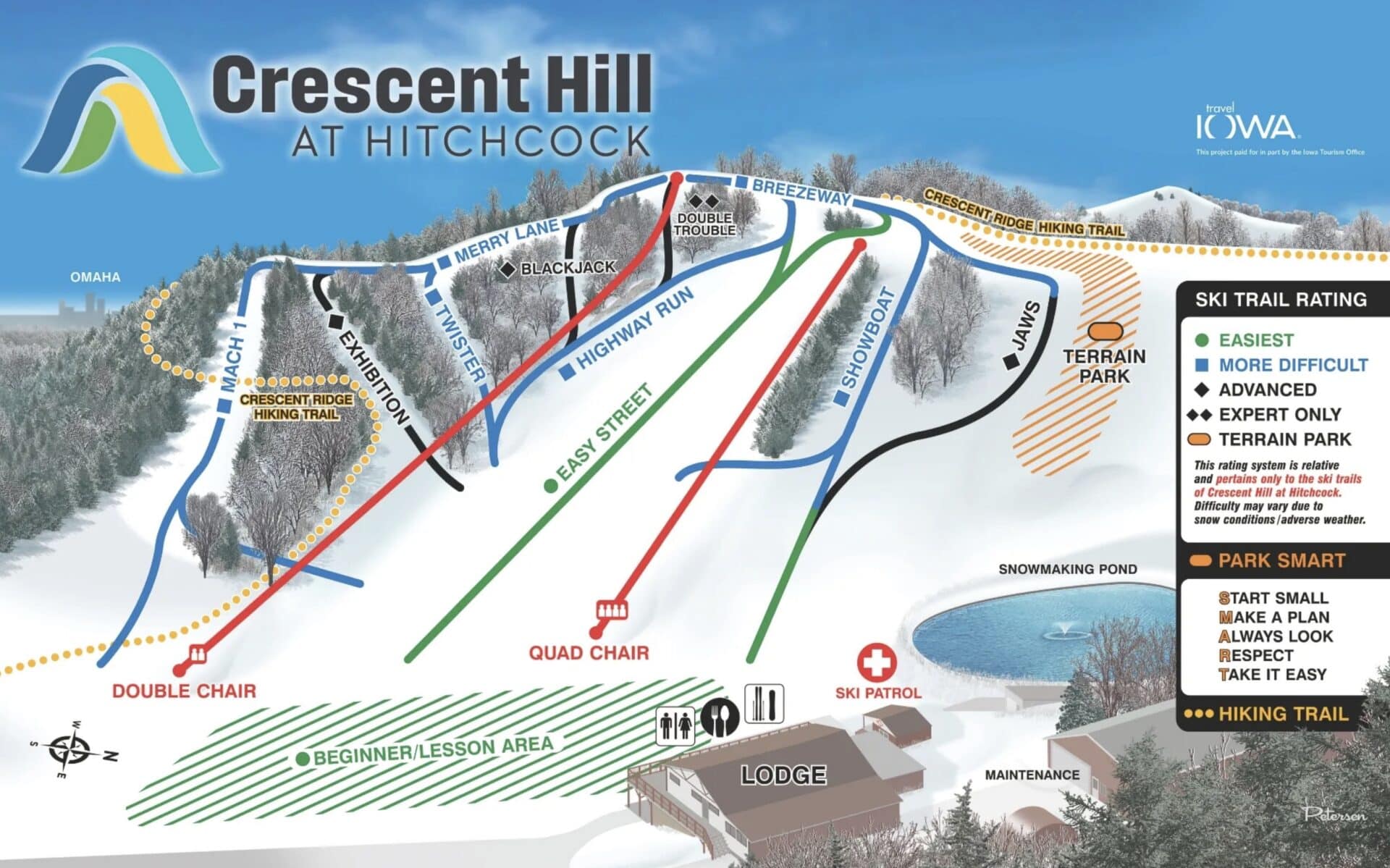
Under new ownership, Crescent Hill at Hitchcock has been strategically integrated with the nearby Hitchcock Nature Center. This strategic alignment aims to enhance the year-round appeal of the area, positioning it as a destination for more than just winter sports. The newly released trail map, a collaborative effort between Dave Petersen and Travel Iowa, highlights this evolving experience. Key features depicted include a new four-season hiking trail and the "Highway Run," a vital connection that links the upper-mountain pistes with the more accessible "Easy Street" piste. This integration underscores a growing trend among resorts to offer diverse recreational opportunities beyond traditional skiing and snowboarding.
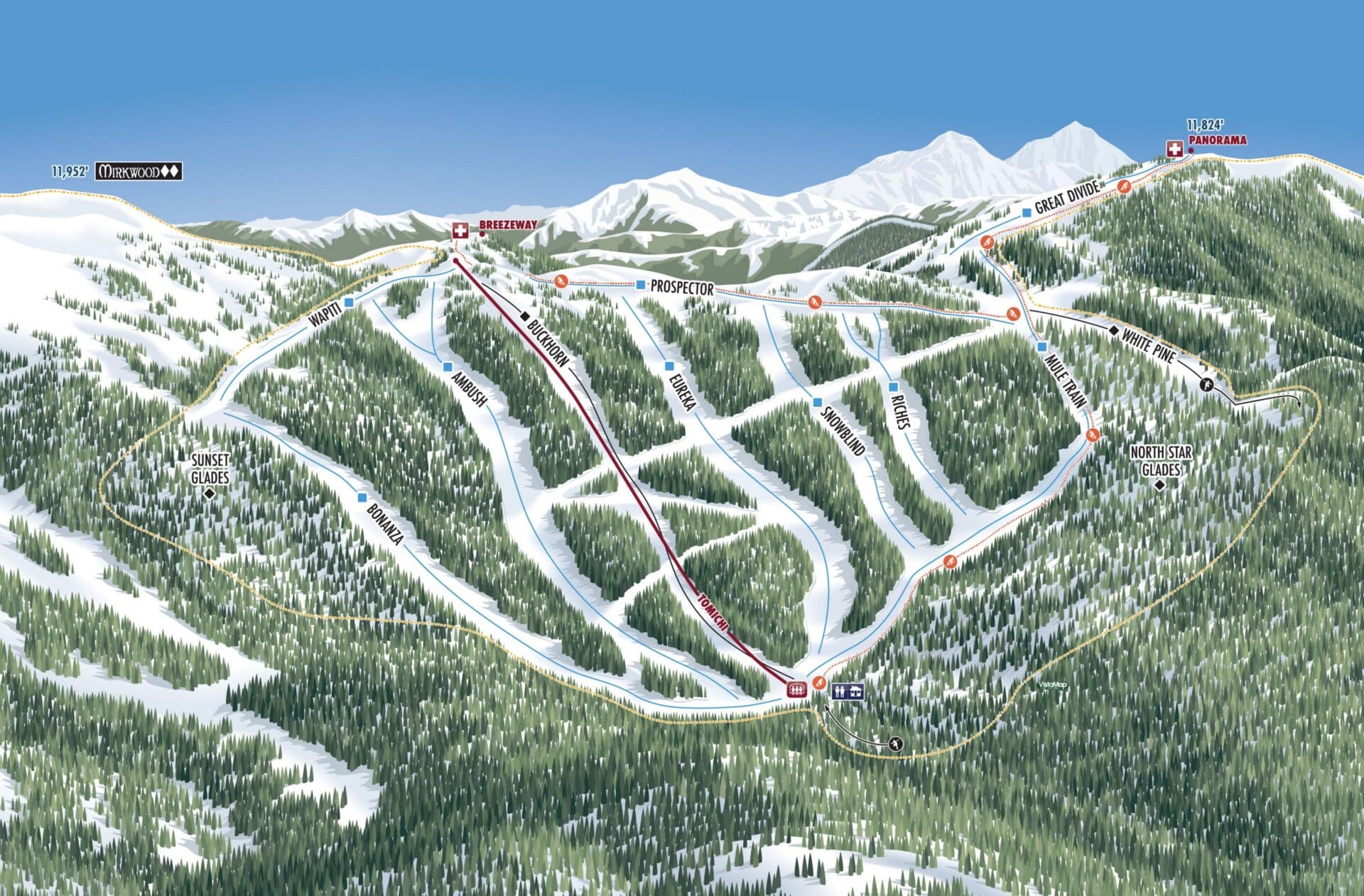
Granby Ranch Transitions to a New Cartographic Style

Granby Ranch has transitioned from a trail map designed by the renowned James Niehues to a new creation by Gary Milliken of VistaMap. This update reflects the resort’s commitment to providing clear and comprehensive information to its guests. The new map meticulously details the various lodging options available on the property, a crucial amenity for visitors planning their stays. Furthermore, it prominently features "Renegade Ridge," a significant new trail experience located on West Mountain, offering skiers and riders fresh challenges and perspectives. The shift in cartographers suggests a desire for a potentially different aesthetic or a more detailed representation of specific resort features.
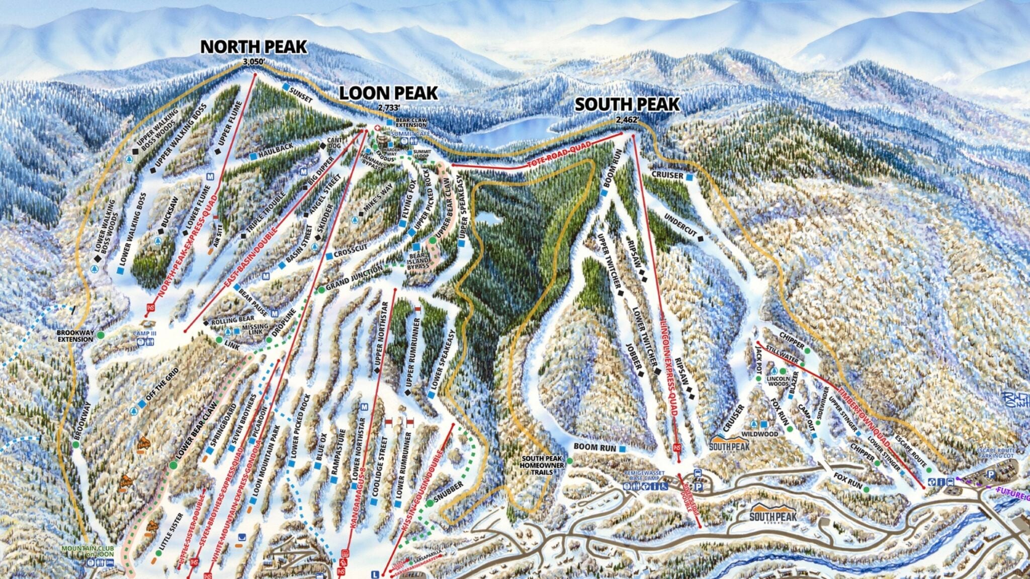
Loon Mountain Focuses on Future Development with Rad Smith
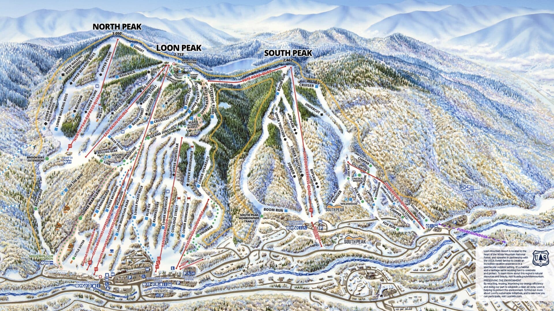
Loon Mountain’s updated trail map, also crafted by Rad Smith, places a pronounced emphasis on the South Peak and Timbertown areas. This strategic focus is indicative of potential significant developments planned for these sections of the mountain in the coming years. By highlighting these zones, the map serves as a visual roadmap for future expansion and upgrades, signaling to skiers and riders the evolving nature of the resort and the exciting prospects ahead. Such forward-looking map designs can generate anticipation and inform long-term visitor planning.
Lusten Mountains Showcases Midwest’s Largest Resort

Lusten Mountains, recognized as the Midwest’s largest ski resort, presents a unique cartographic challenge due to its extensive and complex layout. VistaMap has tackled this challenge with its latest map design, effectively illustrating the sheer scale and offerings of the resort. The map aims to clarify why Lusten Mountains holds its prominent position in the Midwest ski landscape, likely detailing its vast network of trails, lifts, and amenities in a cohesive and understandable manner.
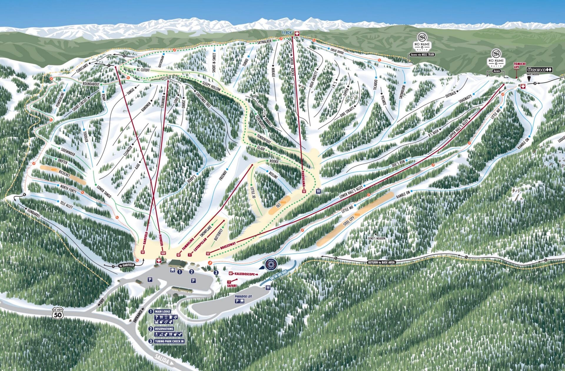
Monarch Mountain Expands with No Name Basin

Colorado’s Monarch Mountain celebrated a significant milestone with the opening of its much-anticipated No Name Basin expansion during the past winter season. To guide visitors through this new terrain, the resort commissioned VistaMap to create an updated trail map. This new map is essential for navigating the newly accessible areas, ensuring skiers and snowboarders can safely explore and enjoy the expanded offerings. The development of No Name Basin represents a substantial investment and a commitment to increasing the resort’s capacity and appeal.
Mt. Abram Modernizes its Cartography and Expands Offerings
Maine’s Mt. Abram has undergone a significant modernization of its trail map, with the new design created in-house by Allie Masten. The updated map provides a clear overview of services available at both base areas and details the routes for uphill skiers and splitboarders, catering to the growing popularity of backcountry and ski touring. Recognizing the diverse recreational needs of its visitors, Mt. Abram has also developed a new map specifically for its expanding bike park, demonstrating a commitment to year-round outdoor activities and a broader customer base.
Mount Jamieson Accurately Depicts Challenging Terrain
Rad Smith has lent his artistic talents to Mount Jamieson in Ontario, addressing a previous cartographic issue where the resort’s map made it appear flatter than it is. The new design by Smith aims to accurately showcase the resort’s steeper sections, providing a more realistic and informative representation for potential visitors. This correction is vital for managing expectations and ensuring skiers and riders can prepare for the mountain’s true character.
Swiss Valley’s New Ownership and Map Refresh

Swiss Valley, a Michigan ski area, is now under new ownership following its acquisition by the Perfect family in 2025. This transition has been accompanied by significant operational changes, including the reintroduction of an old trail and upgrades to snowmaking capabilities. The resort’s new map features a design similar to that of Timberline Mountain, another resort owned by the Perfect family, suggesting a consistent brand identity and a commitment to clear, modern cartography across their properties.
Willamette Pass Streamlines Navigation with Dual Maps

Oregon’s Willamette Pass has addressed prior navigational challenges with a revised trail map designed by Stefan Bast. The previous map was reportedly confusing, lacking clarity regarding future trail developments and Nordic pistes. The new approach separates these elements into two distinct maps: one focusing on the alpine terrain and another for other activities. This strategic division aims to eliminate confusion and provide a more user-friendly experience for all visitors, with further edits anticipated.
Notable Map Modifications and Revisions
Beyond entirely new maps, several resorts have implemented significant modifications to existing ones, reflecting ongoing development and strategic adjustments.

Black Mountain Updates with New Features
New Hampshire’s Black Mountain has experienced substantial changes since its acquisition by Entabeni Systems. For the 2025-26 season, the resort has introduced a new building, the "Sugar Shack," and added challenging new hike-to double-black terrain. The updated trail map, designed by Senan Gorman of North Pole Design, meticulously incorporates these new features, providing skiers with accurate information about the expanded and more challenging offerings at the resort.

Deer Valley Resort Continues its "Expanded Excellence" Project
Deer Valley Resort in Utah unveiled the second phase of its "Expanded Excellence" project last winter, significantly increasing its trail count by approximately 80 new runs and adding seven new lifts. The resort’s new trail map, designed by Rad Smith and released in late 2024, now accurately reflects these additions. Previously, these areas were depicted with a general green overlay, but the updated map includes specific trail names and lift designations. An additional shaded area, Hail Peak, is slated for potential debut next winter, suggesting that further map revisions may be on the horizon. This phased expansion highlights a long-term strategy to enhance the resort’s already extensive offerings.

Powder Mountain’s Powder Haven Introduces Membership-Based Access
Powder Mountain’s private side, Powder Haven, has seen a notable update to its James Niehues-designed map. The revision introduces a visual distinction for lifts accessible exclusively to Powder Haven members, marked by orange shading. This change reflects the installation of three new lifts and the conversion of two existing lifts (Mary’s and Village) to private access. With plans for three new lifts on the public side and two more on the private side next winter, the map is likely due for further refreshes to accurately represent these ongoing developments. This expansion of private terrain underscores a growing trend in the ski industry, catering to exclusive experiences.

Anticipating Future Cartographic Innovations
The landscape of ski resort maps is continuously evolving, driven by infrastructure development, technological advancements, and a desire to enhance the guest experience.
Upcoming Projects from Leading Cartographers

Rad Smith, a prominent name in ski resort map design, has a robust pipeline of upcoming projects. These include new maps for Brian Head, Montage Mountain, and Sundance. These upcoming releases will likely showcase similar artistic detail and functional clarity that have become hallmarks of Smith’s work, providing skiers and riders with essential navigational tools as these resorts grow and adapt. The inclusion of new terrain and updated amenities in these maps will be critical for informing visitors and shaping their on-mountain experience.
The continuous release of updated and redesigned trail maps signifies a healthy and dynamic ski industry. Resorts are not only investing in physical infrastructure but also in the clarity and artistry of their cartographic representations. These maps are more than just guides; they are an integral part of the mountain experience, offering a visual narrative of adventure, discovery, and the ever-evolving spirit of winter recreation. As technology advances and resorts continue to expand, we can anticipate even more innovative and informative trail maps in the seasons to come, further enriching the journey for every skier and rider.

Image/Video Credits: Big Rock, Crescent Hill at Hitchcock, Granby Ranch, Loon Mountain Resort, Monarch Mountain, Mt. Abram, Mount Jamieson, Paul Bunyan, Troll Resort, Swiss Valley, Willamette Pass, Black Mountain, Deer Valley Resort, Powder Haven.
