
The Northwest Avalanche Center (NWAC) is spearheading a significant national initiative to overhaul and modernize the delivery of avalanche forecasts and critical mountain weather information. This ambitious undertaking, driven by NWAC’s dedicated technology team, known as Avy, involves a broad collaboration among avalanche centers across the United States. The core objective is to develop and implement shared digital tools that will enhance the accessibility, consistency, and effectiveness of vital safety data for all backcountry enthusiasts. This initiative represents a paradigm shift from historically fragmented and often duplicated efforts to a unified, technology-driven approach designed to improve public safety in mountainous regions.
The Avy initiative is comprised of two primary product streams, each designed to cater to different user needs and technological platforms. While the specific details of these products were not elaborated upon in the initial announcement, the overarching goal is to create a seamless and intuitive experience for accessing avalanche forecasts, weather data, and related safety information. This includes leveraging advancements in web and mobile technology to ensure that crucial information is readily available to a wider audience, regardless of their technical proficiency or geographical location. The emphasis is on creating a user-centric ecosystem that prioritizes clarity, accuracy, and ease of access.
NWAC’s Strategic Position in Leading the Technological Advancement
NWAC’s proactive role in driving technological innovation is intrinsically linked to its fundamental mission: to broaden access to backcountry forecasts and essential education. By embracing and advancing digital platforms, NWAC aims to make vital safety information more accessible through multiple modalities, thereby reaching a more diverse spectrum of users. This includes not only seasoned backcountry professionals but also recreational skiers, snowboarders, hikers, and anyone venturing into mountainous terrain where avalanche hazards exist.
The foundation for this collaborative effort was laid by the Avalanche Forecast Platform (AFP). Developed and utilized by nearly all avalanche centers in the U.S., the AFP serves as the backbone for forecasters to publish their critical analyses, manage field observations, and perform other essential duties. The AFP’s success in fostering inter-center cooperation demonstrated the potential for greater efficiency and effectiveness when resources and expertise are pooled. Recognizing this precedent, NWAC, as one of the largest and most well-resourced centers utilizing the AFP, identified a strategic opportunity to extend this collaboration beyond internal forecasting processes to the development of user-facing digital tools. This vision recognizes that the collective strength of the avalanche community can achieve far more than individual efforts.
The Power of Collaboration: Unifying Efforts Over Duplication

The core philosophy underpinning the Avy initiative is "collaboration over duplication." This approach is driven by the understanding that a unified system allows for the strategic leveraging of technology best practices, sophisticated design insights, and aggregated data to continuously improve the user experience. NWAC firmly believes that consistency in forecasting products is a significant benefit for all backcountry users. When individuals can access reliable and uniformly presented information from different regions, their ability to make informed decisions is greatly enhanced, leading to a safer outdoor experience.
Historically, the landscape of avalanche forecasting websites was characterized by fragmentation. Each avalanche center typically managed its own website, often requiring complete rebuilds every five to seven years. This model presented significant challenges, particularly for smaller centers with limited budgets. Staff members were often required to possess advanced technical expertise or the centers had to allocate scarce financial resources to hire external technical consultants. This constant cycle of development and maintenance diverted valuable time and energy away from the core mission of forecasting and public safety education.
By pooling their collective resources and expertise, smaller avalanche centers can now gain access to advanced technological solutions that would otherwise be beyond their financial and operational reach. Simultaneously, NWAC benefits from the invaluable feedback and shared investment provided by its partner centers. The Avy team, by centralizing the technological development and maintenance, liberates avalanche center staff to concentrate on their specialized skills: analyzing snowpack conditions, interpreting weather patterns, conducting field observations, and communicating critical safety messages. This division of labor optimizes the strengths of each component of the national avalanche forecasting network.
Current Status and Progress of the Avy Initiative
Both AvyWeb and AvyApp have been successfully launched and are currently operating in a stable state. This initial deployment has established a solid foundation upon which new functionalities and enhancements will be built. NWAC emphasizes a cautious and deliberate approach to future development, ensuring that every investment of resources is strategically aligned with maximizing user benefit and long-term sustainability. This measured pace is intended to prevent the misallocation of funds and to ensure that the developed tools are robust, reliable, and truly meet the needs of the backcountry community.
AvyApp has reached a stable point in its development, allowing the team to begin prioritizing the implementation of new features. The adoption rate of AvyApp is a testament to its utility and the growing need for accessible avalanche information. Currently, an impressive 15 avalanche centers have integrated with the app, demonstrating a significant level of national buy-in and user engagement. This widespread adoption signifies a crucial step towards a unified national platform for avalanche safety.
On the AvyWeb front, two prominent centers, the Sierra Avalanche Center and the Sawtooth Avalanche Center, have successfully launched on Version 1 of the platform. Furthermore, a dedicated course catalog for the American Avalanche Association has been developed. This course catalog is designed to be embeddable across various online platforms, ensuring that avalanche education opportunities are widely disseminated. Plans are underway to integrate this catalog into avalanche center websites nationwide, further expanding its reach. The development team is currently focused on refining existing features, implementing general enhancements, and addressing smaller, incremental improvements. Following this phase, the team will transition to a period of focused maintenance and bug fixing during the upcoming holiday season, with a temporary pause on the introduction of new features. This strategic break will allow for thorough testing and stabilization before ramping up new development efforts in the new year.
Future Roadmap and Vision for Avy
The roadmap for the Avy initiative is extensive, outlining a series of ambitious features and enhancements designed to further revolutionize avalanche forecasting and mountain safety. The successful execution of these future developments is critically dependent on the continued reliance on unified platforms, fostering an environment of shared progress and innovation. NWAC itself is slated to transition to the new Avy platform during the 25/26 season, marking a significant milestone in the adoption of these advanced tools by its originating center.
AvyApp: Enhancements on the Horizon
The future development of AvyApp is focused on enriching the user experience with advanced functionalities that cater to the dynamic needs of backcountry users. Key planned features include:
- Enhanced Weather and Avalanche Data Visualization: The app will feature more sophisticated graphical representations of weather trends, snowpack conditions, and avalanche risk levels. This will include interactive charts and maps that allow users to visualize data over time and across different geographical areas, enabling more nuanced risk assessment. For example, historical weather data coupled with current snowpack observations can provide crucial context for understanding potential avalanche hazards.
- Real-Time Observation Reporting: A streamlined and intuitive system for users to submit real-time observations from the field will be implemented. This crowdsourced data will provide avalanche forecasters with invaluable, up-to-the-minute information, enhancing the accuracy and timeliness of forecasts. This feature could include photo uploads, standardized reporting formats, and GPS integration for precise location data.
- Personalized Alerts and Notifications: Users will be able to customize alerts based on their specific locations, planned routes, and risk tolerance. This could include notifications for significant changes in avalanche danger, critical weather events, or new forecast updates relevant to their intended backcountry activities. This proactive approach aims to keep users informed without overwhelming them with unnecessary information.
- Offline Map and Data Access: Recognizing the intermittent connectivity in remote mountainous areas, AvyApp will offer robust offline capabilities. Users will be able to download maps, forecasts, and other essential data for access without an internet connection, ensuring safety even in areas with limited cellular service. This is a critical safety feature for any backcountry application.
- Integration with Wearable Technology: Future iterations may explore integration with smartwatches and other wearable devices, allowing for quick access to critical safety information and the ability to log observations without needing to pull out a smartphone. This seamless integration can be vital in emergency situations.
AvyWeb: Expanding Capabilities and Reach
AvyWeb is also poised for significant expansion, aiming to become a comprehensive online portal for avalanche safety information and resources. Key planned features include:
- Interactive Terrain and Hazard Mapping Tools: Advanced mapping tools will allow users to explore detailed terrain features, identify avalanche runout zones, and visualize hazard areas in conjunction with current forecast data. This could include overlaying historical avalanche incident data, slope angle analysis, and aspect-specific risk assessments.
- User-Generated Content and Community Forums: The platform will foster a sense of community by enabling users to share trip reports, photos, and insights. Moderated forums will provide a space for discussion, knowledge sharing, and peer-to-peer advice on backcountry safety practices. This can be a valuable source of localized knowledge and experience.
- Streamlined Observation Submission Portal for Forecasters: While AvyApp focuses on public observation submission, AvyWeb will offer a robust and efficient portal for professional forecasters to manage and analyze incoming data, generate detailed reports, and collaborate on forecast development. This internal-facing tool is crucial for the operational efficiency of avalanche centers.
- Comprehensive Educational Resource Hub: Beyond the course catalog, AvyWeb will serve as a central repository for a wide range of educational materials, including articles, videos, tutorials, and best practice guides on avalanche safety, snowpack assessment, and backcountry travel techniques. This aims to be a one-stop shop for all avalanche-related learning.
- Data Analytics and Reporting for Centers: The platform will provide advanced analytical tools for avalanche centers to track trends, assess the effectiveness of their forecasts, and generate comprehensive reports for stakeholders and funding agencies. This data-driven approach will support continuous improvement and accountability.
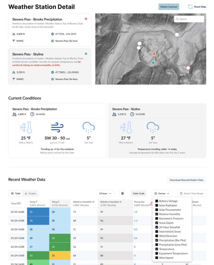
Mockups Illustrate Future Functionality and Design
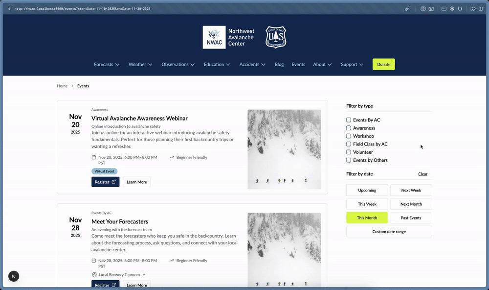
The provided mockups offer a compelling glimpse into the future design and functionality of the Avy initiative. The visual representations of weather stations, event displays, and app interfaces suggest a commitment to a clean, intuitive, and information-rich user experience. For instance, the weather station mockups demonstrate a clear and concise presentation of crucial meteorological data, likely including temperature, wind speed and direction, precipitation, and humidity. The event mockups hint at the ability to effectively communicate important advisories, warnings, and educational events to the public in an engaging and easily digestible format. The app mockups showcase a modern and user-friendly interface, emphasizing clear navigation and the prominent display of critical safety information, such as avalanche danger ratings and recent observations. These visual previews underscore the intentionality behind the design process, aiming to translate complex data into actionable insights for backcountry users.
Broader Impact and Implications
The Avy initiative represents a significant advancement in the field of avalanche safety and forecasting. By creating a unified, technologically advanced, and collaborative national system, NWAC and its partner centers are poised to:
- Enhance Public Safety: More accessible, consistent, and effective information directly translates to better-informed decisions by backcountry users, thereby reducing the risk of avalanche accidents. The availability of real-time data and personalized alerts can be life-saving.
- Improve Operational Efficiency: Streamlining technological development and maintenance frees up valuable resources for avalanche centers to focus on their core expertise in forecasting and education. This efficiency is crucial for the sustainability of these vital services.
- Promote National Consistency: A standardized approach to information delivery ensures that backcountry users receive a comparable level of safety data, regardless of their location within the United States. This is particularly important for individuals who travel across different regions.
- Foster Innovation: The collaborative nature of the Avy project encourages the sharing of ideas and best practices, driving continuous innovation in avalanche forecasting and safety technology. This collective intelligence is a powerful engine for progress.
- Strengthen the Backcountry Community: By providing robust digital tools and fostering a sense of community, the initiative can empower backcountry users with the knowledge and resources they need to explore the mountains safely and responsibly.
The success of the Avy initiative hinges on sustained collaboration, ongoing technological development, and the active engagement of avalanche centers and the backcountry community. As NWAC continues to lead this charge, the future of avalanche safety information delivery appears brighter and more integrated than ever before. The commitment to a unified, user-centric approach signifies a profound dedication to protecting lives and enhancing the experience of those who venture into America’s magnificent mountain landscapes.