
The Northwest Avalanche Center (NWAC) is at the forefront of a significant initiative to overhaul and modernize how avalanche and mountain weather forecasts are disseminated across the United States. Through its dedicated technology arm, known as Avy, NWAC is spearheading a collaborative endeavor involving numerous avalanche centers nationwide. The primary objective is to develop shared digital tools that will enhance the accessibility, consistency, and overall effectiveness of critical safety information for all mountain enthusiasts.
Avy, the technological innovation driving this transformation, comprises two key components: AvyWeb and AvyApp. These platforms are designed to streamline the user experience and provide a more unified approach to forecasting. The development and rollout of these tools represent a substantial leap forward from the fragmented and often outdated systems previously employed by individual avalanche centers.
The Genesis of NWAC’s Leadership in Technological Advancement
NWAC’s commitment to technological innovation is deeply ingrained in its operational mission. By expanding the reach and usability of backcountry forecasts and educational resources, the center aims to foster a safer environment for all who venture into avalanche terrain. This focus on accessibility, particularly through multiple digital modalities, is crucial for reaching a diverse user base, from seasoned professionals to recreational users.
Historically, the vast majority of U.S. avalanche centers have relied on a common platform known as the Avalanche Forecast Platform (AFP). This system serves as a foundational tool for forecasters, enabling them to publish forecasts, manage field observations, and perform other essential tasks. The AFP laid the groundwork for inter-center collaboration, demonstrating the potential benefits of shared resources. Recognizing its position as one of the largest and most well-resourced centers utilizing the AFP, NWAC identified a strategic opportunity to build upon this existing cooperation by developing user-facing digital tools that would benefit all participating centers.
A Paradigm Shift: Collaboration Over Duplication in Forecasting Technology
The overarching principle guiding this initiative is collaboration, aiming to replace the inefficiencies and redundancies of individual development. By fostering a unified system, avalanche centers can collectively leverage best practices in technology, harness design insights from a broader user base, and aggregate data to continuously improve the user experience. This commitment to consistency in forecasting products is anticipated to significantly benefit all backcountry users by providing a more predictable and reliable information stream.

The historical landscape of avalanche forecasting websites was characterized by each center independently managing its own digital presence. This often involved rebuilding websites from scratch every five to seven years, a process that was both resource-intensive and demanded significant technical expertise. Many smaller centers, operating with limited budgets, struggled to maintain cutting-edge websites or even hire dedicated technical staff. This often meant that avalanche center personnel, whose primary expertise lies in snow science and forecasting, were diverted to manage complex technological infrastructure.
The current collaborative approach, spearheaded by NWAC, addresses these challenges directly. By pooling resources and expertise, smaller avalanche centers gain access to advanced technological capabilities that would otherwise be unattainable. In return, NWAC benefits from the valuable feedback and shared investment from these partner centers. The Avy team is tasked with managing the technological backbone, thereby liberating avalanche center staff to concentrate on their core competencies: analyzing snowpack, forecasting avalanche conditions, and educating the public.
Current Status of the Avy Initiative
Both AvyWeb and AvyApp have been successfully launched and are currently operating in a stable state, with development teams poised to introduce new functionalities. While the allure of new designs and features is strong, the NWAC-led initiative emphasizes a cautious and deliberate approach to development. This ensures that every dollar invested is utilized efficiently and effectively, prioritizing impactful advancements.
AvyApp has reached a stable operational phase, allowing the team to begin prioritizing the development of new features. This mobile application has already seen significant adoption, with fifteen avalanche centers currently utilizing the platform. This widespread adoption underscores the need and demand for a standardized, user-friendly mobile interface for avalanche information.
On the AvyWeb front, two key avalanche centers, the Sierra Avalanche Center and the Sawtooth Avalanche Center, have successfully launched on Version 1 of the platform. Furthermore, a comprehensive course catalog for the American Avalanche Association has been developed using this platform. This embedded course catalog is designed for seamless integration across the internet and is slated for implementation on avalanche center websites nationwide. The development team is currently focused on refining the existing platform, addressing general development tasks, and implementing smaller feature enhancements. As the holiday season approaches, the focus will shift to maintenance and bug fixing, with a temporary pause on new feature development before resuming accelerated progress in the new year.
Future Trajectory: An Extensive Roadmap for Enhanced Avalanche Safety
The roadmap for Avy’s continued development is extensive and ambitious. Several key features are highlighted as particularly impactful, made possible only through the unified nature of these digital platforms. NWAC itself is projected to transition to the new AvyWeb platform during the 2025-2026 season, marking a significant milestone in its own technological modernization.
AvyApp: Enhancing Mobile Accessibility and Functionality
The future development of AvyApp is focused on several key areas designed to further empower backcountry users with real-time, accessible information. Enhancements are planned to include:
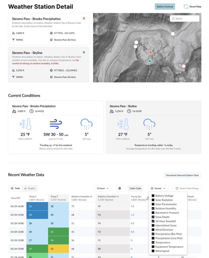
- Real-time weather station data integration: Providing users with immediate access to current weather conditions from various mountain locations. This will likely include detailed information on temperature, wind speed and direction, precipitation, and visibility.
- Enhanced observation submission tools: Streamlining the process for users to submit their own observations of snow conditions, avalanche activity, and other relevant mountain hazards. This crowdsourced data is invaluable for forecasters.
- Personalized alert systems: Allowing users to set up custom alerts for specific regions or conditions of interest, ensuring they receive timely notifications about changing avalanche risks.
- Offline map capabilities: Enabling users to download maps and forecast information for use in areas with limited or no cellular service, a critical feature for remote backcountry travel.
- Integration with wearable devices: Exploring the potential for seamless data sharing and alerts with smartwatches and other wearable technology, further enhancing user convenience and safety.
AvyWeb: A Comprehensive Hub for Avalanche Information
AvyWeb is envisioned as a central, dynamic hub for all avalanche-related information, offering a suite of features designed to cater to a wide range of users and operational needs. Future developments include:
- Interactive forecast maps with layered data: Presenting avalanche forecasts, weather data, and observational information in an easily digestible, interactive map format. Users will be able to layer different data sets to gain a comprehensive understanding of mountain conditions.
- Advanced snowpack modeling visualization: Providing forecasters and informed users with tools to visualize and analyze complex snowpack data, including snow depth, temperature profiles, and potential weak layers.
- Streamlined observation management for forecasters: Enhancing the tools forecasters use to manage, analyze, and integrate field observations into their daily forecasts.
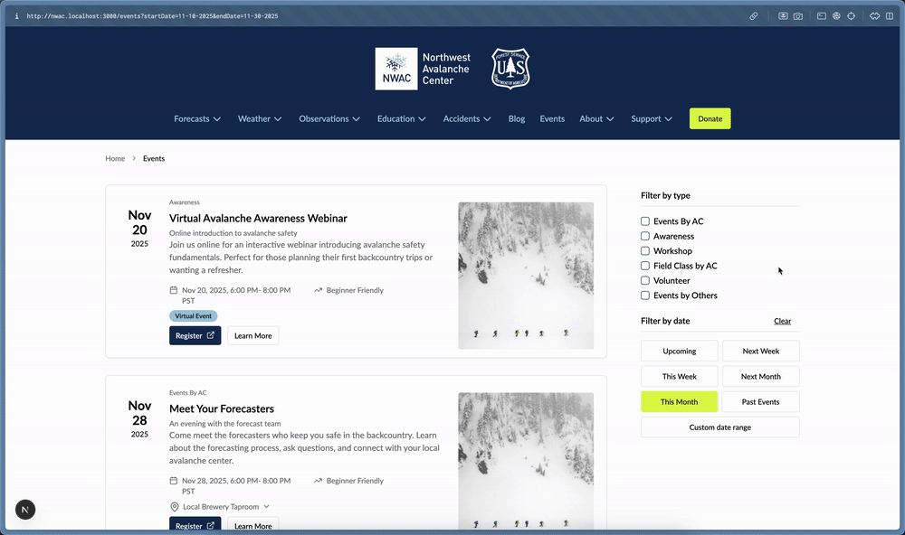
- Public-facing educational resources and tools: Expanding the availability of educational materials, interactive guides, and tools to help the public better understand avalanche risks and safety practices.
- Data analytics and reporting dashboards: Developing robust tools for avalanche centers to analyze trends, track forecast accuracy, and generate reports for research and public outreach.
- Integration with emergency services and rescue organizations: Exploring pathways for better information sharing with SAR teams and other first responders, potentially improving response times and effectiveness in avalanche incidents.
- A unified platform for all U.S. avalanche centers: The ultimate goal is to have all U.S. avalanche centers operating on this standardized, modern platform, ensuring a consistent and high-quality user experience nationwide.
Supporting Data and the Impact of Standardization
The move towards standardized digital tools is supported by several key factors. The National Avalanche Center (NAC) reports that there are approximately 15,000 avalanches that occur each year in the United States. While many of these are small and pose little risk, a significant number can be large and destructive. According to data compiled by the U.S. Forest Service, an average of 30 people die in avalanches in the U.S. each year, with hundreds more being caught or buried. This highlights the critical importance of accurate, timely, and accessible avalanche forecasts.
The current fragmented system, where each center manages its own website and technology stack, leads to inconsistencies in the presentation and accessibility of vital information. This can create confusion for users who travel across different regions. For example, a backcountry skier who is accustomed to the interface and data presentation of one avalanche center’s website might find a different regional center’s site to be less intuitive or informative. This lack of standardization can inadvertently increase risk if users are not able to quickly and accurately interpret the forecast information.
The adoption of AvyWeb and AvyApp aims to mitigate these issues. By providing a consistent user interface and data structure across all participating centers, users can develop a familiarity with the platform, regardless of their geographic location. This familiarity can lead to quicker comprehension of avalanche hazard information, improved decision-making, and ultimately, enhanced safety in the backcountry.
Furthermore, the collaborative development model allows for greater efficiency in resource allocation. Instead of each center expending significant funds and human capital on individual website development and maintenance, these resources can be pooled. This collective investment allows for the development of more sophisticated and robust tools than any single center could afford on its own. The consolidation of development efforts also means that updates, bug fixes, and new features can be rolled out more efficiently and consistently across all participating centers.
Broader Impact and Implications for the Backcountry Community
The implications of NWAC’s leadership in this technological advancement extend far beyond the operational efficiency of individual avalanche centers. This initiative has the potential to fundamentally change how the public interacts with avalanche safety information, fostering a more informed and prepared backcountry community.
For the average backcountry user, the Avy platforms promise a more intuitive and user-friendly experience. The ability to access consistent information across different regions, coupled with potentially enhanced features like offline maps and personalized alerts, can significantly improve situational awareness and risk management. This democratization of advanced technological tools means that even novice backcountry enthusiasts can access sophisticated safety information.
For avalanche forecasters, the new platforms offer improved tools for data analysis, visualization, and communication. This can lead to more accurate and nuanced forecasts, as well as more effective dissemination of critical information to the public. The ability to leverage shared development means that forecasters can focus more on their scientific work and less on the technical intricacies of website management.
The long-term impact of this collaborative approach could also lead to greater standardization in avalanche education and outreach efforts. As more centers adopt these shared digital tools, there may be opportunities to further align educational curricula and messaging, creating a more cohesive and effective national avalanche safety program.
This initiative represents a significant step forward in leveraging technology to enhance public safety in avalanche-prone regions. By fostering collaboration and prioritizing user-centric design, NWAC and its partner avalanche centers are building a more accessible, consistent, and effective system for delivering vital mountain weather and avalanche information, ultimately contributing to a safer experience for all who venture into the backcountry.
