
The winter of 2024-2025 presents a complex meteorological puzzle for the Pacific Northwest, with forecasters emphasizing that a weak La Niña does not automatically guarantee the deep, mid-winter snowpacks many anticipate. This nuanced outlook stems from a deeper understanding of the El Niño-Southern Oscillation (ENSO) cycle and its intricate relationship with regional climate patterns, particularly sea surface temperatures in the Pacific Ocean.
Understanding the ENSO Cycle and its Forecasting
The El Niño-Southern Oscillation (ENSO) is a naturally occurring phenomenon characterized by cyclical fluctuations in tropical Pacific sea surface temperatures, profoundly influencing global weather patterns. ENSO cycles through three distinct phases: El Niño (warm phase), La Niña (cool phase), and Neutral conditions. The effectiveness of these phases in predicting winter weather, especially snowpack accumulation in the Pacific Northwest, is a subject of ongoing scientific scrutiny and refinement.
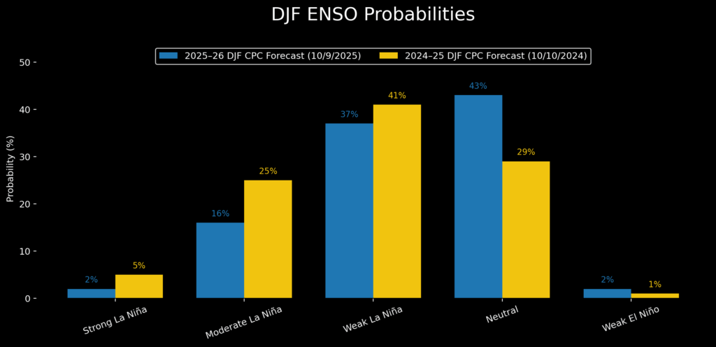
October forecasts for mid-winter ENSO probabilities in 2025-2026 reveal a striking similarity to the previous year’s projections. Both forecasts indicate the highest likelihood of cool-phase conditions during the autumn and early winter months. However, a subtle weakening of the La Niña signal for the upcoming 2025-2026 season has been observed. This suggests that while a cool phase is anticipated, its intensity might be less pronounced than in some previous La Niña events.
The Oceanic Niño Index (ONI) serves as a principal measure for monitoring and predicting ENSO. It is calculated based on departures from average sea surface temperatures (SSTs) in the Niño 3.4 region of the Pacific Ocean. For the 2024-2025 season, the December-January-February (DJF) ONI registered -0.6°C, just barely entering the weak La Niña territory. Current data indicates that we are again on the cusp of a weak La Niña, with the latest weekly SST departure also at -0.6°C.
Forecasted ENSO Conditions for Winter 2025-2026
Mid-October Oceanic SST models suggest a minimum ONI of approximately -0.8°C in November, with values projected to decrease to around -0.3°C by mid-winter (DJF). This trajectory points towards neutral ENSO conditions as the most probable outcome for the upcoming mid-winter snowpack. The implication is that neither a strong El Niño nor a strong La Niña is expected to dominate the winter weather patterns.

Historical Snowpack Response to ENSO Phases
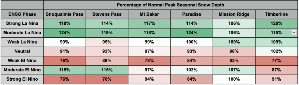
To better understand the potential implications of these ENSO forecasts, researchers have analyzed an updated Snowpack Climatology Dataset for the Pacific Northwest. This dataset provides insights into how mountain snowpack typically responds to different ENSO phase strengths.
Weak La Niña Winters: In past weak La Niña winters, most weather stations in the Pacific Northwest have shown snowpack levels hovering near the historical average. Notable exceptions include Mission Ridge and Timberline, which have exhibited modest gains in snow depth during these periods. This suggests that while weak La Niña conditions may not always lead to exceptional snow accumulation, they can offer some benefit to specific mountain locales.
Moderate to Strong La Niña Winters: The analysis clearly indicates that moderate and strong La Niña years are significantly more favorable for the west slopes and crest of the Cascade Mountains. During these phases, peak snow depths have historically been recorded at 6-24% above normal. These stronger La Niña events are crucial for building substantial snow reservoirs, which are vital for water supply and winter recreation.
Neutral ENSO Years: Neutral ENSO conditions typically result in slightly below-average snowpack across the region. This outcome suggests a more balanced, though not particularly snowy, winter season.
El Niño Winters: Conversely, most El Niño conditions strongly tilt the odds towards reduced snowfall in the Pacific Northwest. This phase often brings warmer and drier weather patterns, impacting snowpack depth and duration.
Analyzing Probabilities for the Upcoming Winter
The DJF distribution of forecast ENSO probabilities for the upcoming winter includes an 18% chance of a moderate to strong La Niña and a mere 2% chance of El Niño. These probabilities, particularly the longer tails of the distribution, can exert a significant influence on the average outcomes.
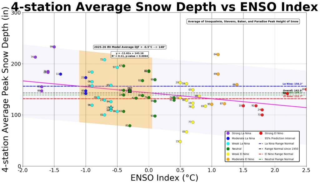
To evaluate the most likely scenarios, researchers focused on the average data from four sites with the longest and most robust historical records: Mt. Baker, Stevens Pass, Snoqualmie Pass, and Paradise.
Recent Snowpack Performance and Climate Trends
The 2024-2025 season saw an average peak snow depth of 114 inches, which represented approximately the 19th percentile for data within the -1 to 0°C ENSO Index interval. This snowpack was 24% below the regression trendline, with reductions particularly noticeable at lower elevation stations, largely attributed to warmer temperatures.
To mitigate the impact of longer-term climate trends, an analysis was also conducted using only 21st-century data. This shortened dataset resulted in a lower mean snow depth across all ENSO phases. However, even with this truncated dataset, the ENSO forecast for the upcoming winter predicts an "almost perfectly average" winter in terms of snowpack.
The Limited Predictive Power of ENSO Alone
Linear best-fit trendlines explain only 11% of the data variability in ENSO versus snowpack plots when including 20th-century data, and 19% when excluding it. This indicates that over 80% of the season-to-season variability in snowpack is not explained by ENSO alone. This highlights the importance of considering other atmospheric and oceanic factors.
The Influence of Marine Heatwaves and Sea Surface Temperatures
Recent reports of a marine heatwave in September have prompted further investigation into the role of sea surface temperatures. A comparative analysis of SSTs from September and October in 2025 against 2024 and 2014 reveals interesting trends. While all three seasons (2014-15, 2024-25, and the projected 2025-26) have exhibited mostly positive anomalies, indicating warmer-than-average conditions, the magnitude and location of these anomalies are critical.
The 2014-2015 season, despite being a very weak El Niño, was characterized by anomalously warm SSTs just off the Pacific Northwest coast. Scientists partially attribute the unusually poor snow year of 2014-2015 to these warm waters, with the four-station average snowpack reading languishing at less than 50% of the values observed in the 2024-2025 season.
While September 2025 began with very warm SSTs across the Northeast Pacific, these waters have since cooled significantly. Proximal waters are now approaching normal levels, a positive sign for potential snow accumulation.
Integrating ENSO with Coastal SSTs for Improved Prediction
A more comprehensive model that combines ENSO phase with nearshore West Coast Marine waters (often referred to as "The Blob") has shown promise in explaining snowpack variability. This combined model can account for approximately 25% of the inter-seasonal variability in snowpack.
The potential for an eastward spread of extraordinarily warm waters in the western North Pacific remains a factor to monitor. However, as long as these exceptionally warm waters remain west of Hawaii, the Pacific Northwest is likely to remain in the negative phase of the Pacific Decadal Oscillation (PDO).
The Pacific Decadal Oscillation (PDO) and its Correlation with Snowfall
The State Climate Office notes that a negative PDO phase correlates with cooler, snowier periods for the region. An analysis of the PDO versus ENSO phase explains approximately 20% of the snowpack variance. This suggests that while ENSO plays a role, the broader, longer-term PDO cycle also significantly influences winter weather patterns.
Conclusion: A Call for Sustained Favorable Conditions
Forecasting winter snowpack in the Pacific Northwest is a complex endeavor, with ENSO and regional sea surface temperatures explaining, at best, around 25% of the variability observed in a 75-year dataset. The impending winter is likely to feature a weak La Niña that could transition into neutral conditions by mid-winter. This scenario portends a fairly typical snowpack for the region.
The probability of a moderate or strong La Niña remains low. However, should such an event materialize, it would significantly increase the likelihood of deeper snowpacks. Regional sea surface temperatures have cooled to near-normal levels, offering some encouragement. Nevertheless, the presence of surrounding warm waters may limit the potential for further cooling.
Ultimately, achieving significantly above-average snowpacks will depend on a confluence of favorable conditions: sustained upwelling off the coasts of South America and North America, continued cool-phase PDO conditions, and robust marine ecosystems supporting healthy fish populations. Ski resorts, water resource managers, and outdoor enthusiasts will be closely watching these indicators as the winter season unfolds.
Disclaimers: This analysis is based on current scientific understanding and forecasts, which are subject to change. Snowpack accumulation is influenced by numerous dynamic factors, and precise predictions remain challenging.
