
A significant and unseasonable winter storm is set to sweep across Colorado, beginning Tuesday and extending into Wednesday, prompting the National Weather Service (NWS) to issue a comprehensive suite of alerts, including Winter Storm Warnings, Watches, and Advisories, across large portions of the state. This late-season event has the potential to deliver substantial snowfall, particularly to the high country, disrupting travel and posing risks of power outages.
Northern Mountains Face Most Intense Conditions Under Winter Storm Warnings
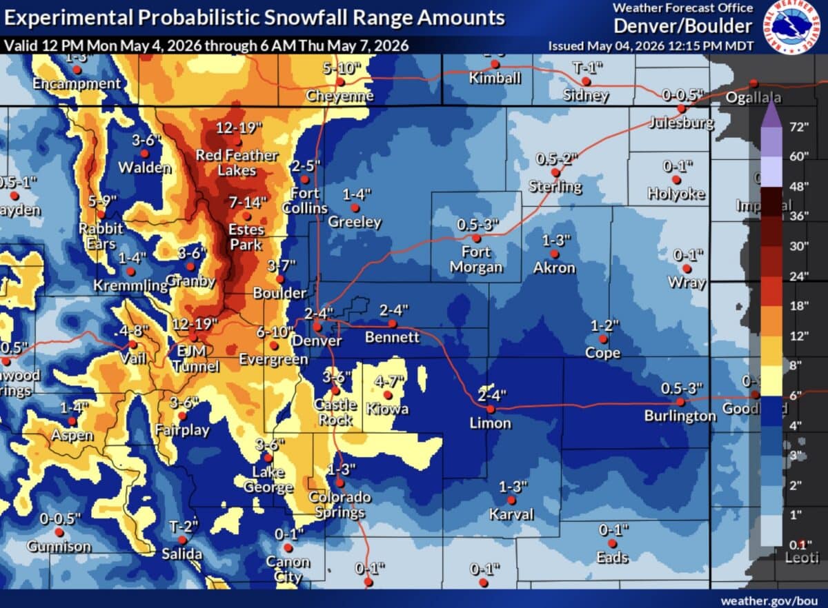
The most severe weather is anticipated for the northern Colorado mountains, where Winter Storm Warnings are in effect from midnight on Tuesday through 3 PM on Wednesday. Areas under this highest level of alert include Rocky Mountain National Park, the Medicine Bow Range, and the northern Front Range foothills. Specific locales such as Red Feather Lakes, Estes Park, and Nederland are expected to experience the brunt of the storm. Forecasts indicate total snow accumulations ranging from 10 to 24 inches, with the heaviest amounts concentrated at elevations above 8,000 feet. The storm’s peak intensity is predicted to occur from Tuesday morning through Tuesday night, bringing challenging conditions for residents and any early-season hikers or campers venturing into these higher elevations.
The NWS office in Boulder, responsible for issuing these warnings, highlighted the unusual nature of such a significant snowfall event this late in the season. Typically, May in Colorado signifies the transition to spring, with warmer temperatures and the melting of existing snowpack. However, atmospheric conditions are aligning to produce a potent winter system, a scenario that necessitates careful preparation and adherence to safety guidelines.

Winter Storm Watches Signal Potential for Widespread Impact
Extending the scope of potential disruption, Winter Storm Watches have been issued for the densely populated Denver metropolitan area and the northern Front Range. This includes major urban centers like Fort Collins, Boulder, Denver, and Castle Rock. These watches are in effect from Tuesday evening through Wednesday afternoon. Forecasters anticipate snowfall totals of three to nine inches within this zone. The distribution of snow is expected to be uneven, with colder surfaces and areas west of Interstate 25 likely to receive more accumulation.
Further west, the Summit County mountains, the Mosquito Range, and the Indian Peaks are also included in the Winter Storm Watch. These mountainous regions could see between six and 18 inches of snow, with the highest accumulations favored along and north of Interstate 70, a critical transportation corridor for both residents and tourists. The potential for heavy snowfall in these areas could impact early spring outdoor recreation activities and further complicate any lingering winter operations at ski resorts.
Winter Weather Advisories for Lesser, Yet Still Significant, Snowfall
A broader segment of Colorado will experience less intense but still noteworthy snowfall under Winter Weather Advisories. This includes popular mountain destinations such as the Vail and Aspen areas, as well as Crested Butte. The Sangre de Cristo Mountains and the Pikes Peak region are also included in these advisories. Even the eastern plains, from Weld County southward into Lincoln County, are under advisement, indicating that the storm’s reach is extensive. Snowfall totals in these advisory areas are expected to vary, generally ranging from one to nine inches, depending on specific elevation and microclimatic conditions. While these amounts may not trigger the same level of concern as the warnings, they are sufficient to cause travel disruptions and create hazardous conditions, particularly on secondary roads and in higher-elevation communities.
Forecasters Warn of Widespread Travel Disruptions and Power Outages
The NWS is issuing a strong cautionary note regarding the potential for hazardous travel conditions across the state. Forecasters are particularly concerned about the accumulation of heavy, wet snow. This type of snow is notoriously problematic as it can weigh down tree branches and power lines, significantly increasing the risk of widespread power outages. The combination of reduced visibility, snow-covered roads, and the potential for downed trees and power lines could make travel "very difficult to impossible" at times, especially during the overnight hours into Wednesday morning.
The Wednesday morning commute along the Front Range, a typically busy period for traffic, is expected to be significantly affected. Residents and commuters are strongly advised to monitor weather updates and, if possible, postpone or cancel non-essential travel during the storm’s most active periods. The potential for significant delays on major highways, including I-70, I-25, and other key arteries, is high.
For those who must travel, real-time information on Colorado road conditions can be accessed through the Colorado Department of Transportation’s (CDOT) website, cotrip.org, or by calling 511. This service provides crucial updates on closures, restrictions, and hazards, enabling travelers to make informed decisions.
Background and Context: An Unseasonable Snowfall Event
The occurrence of a major snowstorm in May in Colorado is not unprecedented, but it is certainly uncommon. Historical weather data reveals that while spring snowstorms can happen, particularly in the higher elevations, the intensity and widespread nature of this forecast event are notable. These late-season storms are often fueled by lingering cold air masses from the north interacting with moisture drawn from the Pacific or, in some cases, from the Gulf of Mexico. The specific atmospheric dynamics at play for this particular storm are still being closely monitored by meteorologists.
The impact of such a storm extends beyond immediate travel concerns. For the agricultural sector, late frosts and snow can damage emerging crops, though the extent of this damage would depend on the duration and severity of the cold temperatures following the snowfall. For the tourism industry, particularly ski resorts that may still be operating, the fresh snowfall could be a welcome boon. However, for many communities, especially those at lower elevations, the primary concern remains the disruption to daily life and potential damage to infrastructure.

Analysis of Implications: A Test for Infrastructure and Preparedness
This late-season winter event presents a unique challenge, testing the resilience of Colorado’s infrastructure and the preparedness of its residents. The potential for heavy, wet snow is a significant concern for utility companies, which will be tasked with responding to outages and repairing damaged lines. Municipalities will need to mobilize snow removal equipment, even as spring cleanup efforts may have already begun.
For individuals, the storm serves as a stark reminder of Colorado’s unpredictable weather patterns. It underscores the importance of having emergency kits, ensuring vehicles are properly equipped for winter driving (even in May), and staying informed about weather alerts. The forecast also highlights the ongoing effects of climate change, which can lead to more extreme and unpredictable weather events. While attributing any single event to climate change is complex, the trend towards more volatile weather patterns is a recognized phenomenon.
The NWS emphasizes that forecasts can change, and residents should continue to monitor updates from official sources. The transition from watches to warnings, and the precise track and intensity of the storm, will become clearer as the event draws nearer. However, the current outlook necessitates a proactive approach to safety and preparedness across a significant portion of the state. The coming days will reveal the full extent of this unseasonable winter’s impact on the Centennial State.
