
The Northwest Avalanche Center (NWAC) is spearheading a significant digital transformation initiative aimed at modernizing and standardizing the delivery of avalanche and mountain weather forecasts across the United States. Through its dedicated technology team, referred to as Avy, NWAC is fostering a collaborative effort among avalanche centers nationwide to develop shared digital tools. This endeavor seeks to enhance the accessibility, consistency, and effectiveness of critical safety information for all backcountry enthusiasts.
The Avy initiative encompasses two primary product streams: AvyWeb, a web-based platform, and AvyApp, a mobile application. These tools are designed to streamline the process of accessing and disseminating vital safety data, moving away from fragmented, individual approaches that have historically characterized the avalanche forecasting landscape.
The Imperative for NWAC’s Leadership
NWAC’s commitment to technological innovation is deeply interwoven with its core mission: to broaden access to backcountry forecasts and educational resources by making them available through multiple, user-friendly modalities. This proactive approach is crucial in an era where increasing numbers of individuals are venturing into mountainous terrain, necessitating clear, reliable, and easily digestible safety information.
A foundational element of this collaborative effort is the Avalanche Forecast Platform (AFP), a shared tool utilized by nearly all avalanche centers in the U.S. The AFP serves as the primary system for forecasters to publish detailed forecasts, manage observations, and perform other essential tasks. Its successful implementation has laid the groundwork for greater inter-center cooperation, demonstrating the potential of shared infrastructure.
Recognizing its position as one of the largest and most resource-rich centers utilizing the AFP, NWAC identified a strategic opportunity to advance this collaboration further by developing user-facing tools that would benefit the entire network. This leadership role underscores NWAC’s dedication to not only improving its own operations but also to elevating the safety standards for backcountry users nationwide.

Collaboration as the Cornerstone: Moving Beyond Duplication
The overarching philosophy driving the Avy initiative is one of collaboration over duplication. By consolidating efforts and resources, the network of avalanche centers can leverage collective technological best practices, design insights, and aggregated data to continuously improve the user experience. This unified approach promotes consistency in forecasting products, a benefit that resonates positively with all individuals who rely on this information for their safety in the backcountry.
Historically, the model for avalanche centers involved independent development and maintenance of their own websites. This often meant rebuilding digital platforms from scratch every five to seven years, a costly and time-consuming process. Such an undertaking frequently demanded that staff possess specialized technical expertise or required limited budgets to hire external technical professionals. This fragmented approach led to inefficiencies and variations in the quality and accessibility of information.
The adoption of shared digital tools through the Avy initiative fundamentally alters this paradigm. Smaller avalanche centers, which may lack the resources to develop and maintain sophisticated digital platforms independently, now gain access to advanced technology. Simultaneously, NWAC benefits from the valuable feedback and shared investment from these participating centers, fostering a mutually beneficial ecosystem. The Avy team’s focus on technological development allows avalanche center staff to concentrate on their primary expertise: forecasting, field observations, and public education.
Current Status and Achievements
Both AvyWeb and AvyApp have been successfully launched and have achieved a stable operational status, setting the stage for the implementation of new functionalities. While the prospect of novel designs and features is exciting, the NWAC emphasizes a cautious and strategic approach to development, ensuring that every invested dollar is utilized efficiently and effectively to deliver maximum value to users.
AvyApp, the mobile application, has reached a stable point where the prioritization of new features is actively underway. Currently, fifteen avalanche centers have adopted the AvyApp, indicating a growing momentum and acceptance of the platform within the forecasting community. This widespread adoption signifies a crucial step towards a more unified mobile presence for avalanche safety information.
On the AvyWeb front, significant progress has been made. The Sierra Avalanche Center and the Sawtooth Avalanche Center have successfully launched their respective websites utilizing Version 1 of the platform. Furthermore, a dedicated course catalog for the American Avalanche Association has been developed. This catalog is designed to be seamlessly embedded into various websites, with plans for nationwide integration into avalanche center websites in the near future. The development team is currently engaged in extensive polishing, general development, and the implementation of smaller features. As the holiday season approaches, the focus will shift to maintenance and bug fixing, with a temporary pause on new feature development to ensure a robust system before resuming accelerated development in the new year.
The Road Ahead: Vision and Future Development
The roadmap for the Avy initiative is extensive and ambitious, with several key features poised to enhance the user experience and expand the capabilities of the platform. The successful realization of these future developments is contingent upon the continued success and adoption of the unified platforms. Notably, NWAC itself is slated to transition to the new website during the 2025-2026 season, marking a significant milestone in the project’s lifecycle.
AvyApp: Enhancements in Mobile Accessibility
Future developments for AvyApp are centered on providing an even more comprehensive and intuitive mobile experience for backcountry users. Key enhancements planned include:
- Real-time Location-Based Forecasts: Users will be able to access highly localized avalanche and weather forecasts based on their current geographical position. This feature will significantly improve the relevance and immediacy of safety information.
- Interactive Map Layers: The app will feature enhanced interactive map capabilities, allowing users to visualize avalanche hazard zones, recent observations, and weather patterns with greater clarity. This will include layers for slope angle, aspect, and elevation, providing critical context for decision-making.
- Offline Mode Enhancements: Recognizing the often-limited connectivity in mountainous regions, further development will focus on robust offline functionality, ensuring that critical data remains accessible even without an internet connection.
- Push Notifications for Critical Alerts: Users will receive timely push notifications for significant changes in avalanche danger levels, severe weather warnings, or other critical safety advisories relevant to their chosen areas of interest.
- User-Submitted Observation Integration: A streamlined process for users to submit their own observations and reports from the field will be implemented, contributing to a richer, crowdsourced dataset for forecasters and the community.
AvyWeb: Expanding the Digital Footprint
AvyWeb is set to evolve into a more dynamic and comprehensive platform, offering a wider array of tools and information. Planned advancements include:
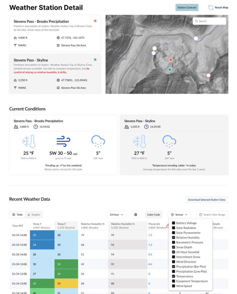
- Dynamic Weather Station Data Integration: The platform will integrate real-time data from weather stations, providing users with up-to-the-minute information on temperature, wind speed and direction, precipitation, and other critical meteorological parameters. Mockups for this feature showcase an intuitive display of weather station data, including historical trends and visual representations of current conditions.
- Advanced Hazard Mapping Tools: Future iterations will incorporate more sophisticated hazard mapping tools, allowing for detailed analysis of avalanche terrain, snowpack stability, and potential avalanche runout zones. This will empower users with a deeper understanding of the risks associated with specific routes and areas.
- Personalized Alert Settings: Users will have the ability to customize alert preferences, receiving notifications for specific regions, danger levels, or types of avalanche activity that are most relevant to their plans.
- Integrated Education Module: The web platform will feature an expanded and easily navigable education module, offering a centralized repository of avalanche safety courses, educational materials, and best practice guides. This will further support NWAC’s mission of fostering a well-informed backcountry community.
- Social Sharing and Community Features: The platform may incorporate features that allow users to share forecasts, observations, and trip plans with their network, fostering a sense of community and shared responsibility for safety.
Visualizing the Future: Mockups and Work in Progress
The ongoing development is being guided by visual mockups that illustrate the intended user experience and functionality of the forthcoming features. These visual aids provide a tangible representation of the advancements to come.
One set of mockups showcases the planned integration of weather station data. These visuals depict a clear and organized display of meteorological information, including charts and graphs that illustrate current conditions and historical trends. The design prioritizes immediate comprehension, allowing users to quickly assess the weather situation relevant to their backcountry activities.
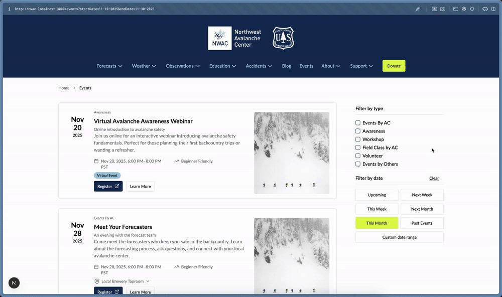
Another compelling visual is an animated GIF demonstrating the proposed functionality for event listings. This mockup highlights an intuitive interface for discovering and accessing information about avalanche safety events, workshops, and educational opportunities. The animated nature of the mockup provides a dynamic preview of how users will interact with this feature, emphasizing ease of navigation and information retrieval.
A third set of mockups focuses on the AvyApp interface, illustrating the planned enhancements to the mobile experience. These visuals showcase a clean and modern design, with intuitive navigation and a clear presentation of essential avalanche and weather information. The mockups highlight features such as interactive maps, simplified data visualization, and streamlined access to critical safety alerts, all tailored for a mobile environment.
Broader Impact and Implications
The Avy initiative represents a significant step forward in the national effort to enhance backcountry safety. By standardizing and modernizing forecasting tools, NWAC and its collaborating avalanche centers are creating a more cohesive and reliable information ecosystem. This collaboration not only optimizes resource allocation but also ensures that backcountry users across the country have access to consistent, high-quality safety information, regardless of their geographic location.
The implications of this project are far-reaching. As the number of individuals participating in backcountry activities continues to grow, the demand for accessible and accurate safety information intensifies. The Avy initiative directly addresses this demand by making critical data more readily available and understandable. This improved accessibility has the potential to reduce avalanche-related incidents and fatalities, fostering a safer environment for all who venture into the mountains.
Furthermore, the collaborative model employed by NWAC serves as a blueprint for other organizations facing similar challenges in digital infrastructure and information dissemination. By pooling resources and expertise, these groups can achieve greater impact and efficiency than they could through individual efforts. The success of Avy is poised to inspire further innovation and cooperation within the broader outdoor recreation and public safety sectors, ultimately contributing to a more informed and safer world. The commitment to user-centric design and continuous improvement ensures that these digital tools will remain relevant and effective for years to come, supporting the ever-evolving needs of the backcountry community.
