
A Winter Weather Advisory is in effect for the mountainous regions of southern Wyoming, with forecasters predicting significant snowfall accumulations of up to a foot in the Sierra Madre and Snowy Range. The advisory, issued by the National Weather Service (NWS) in Cheyenne, is active until 3 p.m. Mountain Daylight Time on Tuesday. This late-season snowfall poses potential hazards for outdoor enthusiasts and motorists traversing the affected areas.
Snowfall Projections and Timing
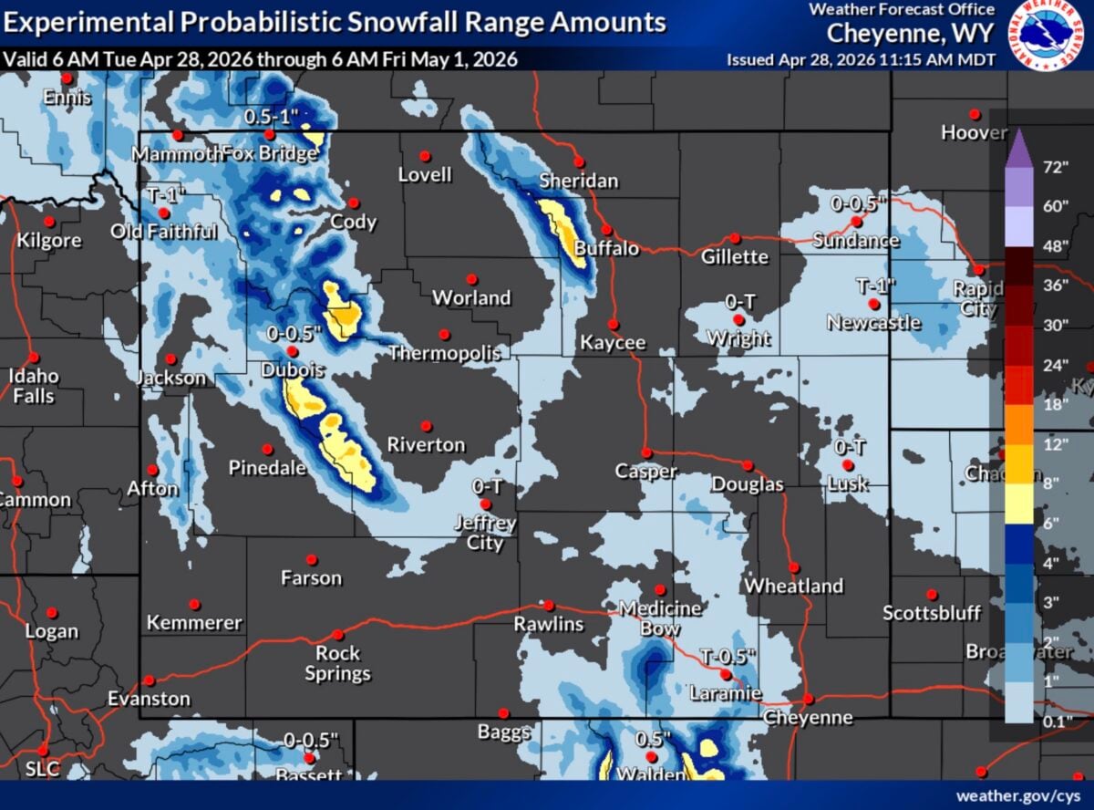
The NWS Cheyenne office has detailed forecasts indicating that total snow accumulations are expected to range between 6 and 12 inches. Higher amounts, potentially exceeding a foot, are anticipated at the highest elevations within the Sierra Madre and Snowy Range. The snowfall began to ease through the morning hours on Tuesday, but a second wave of precipitation is expected to move in during the afternoon. This renewed activity is forecast to continue until the advisory’s expiration at 3 p.m. MDT.
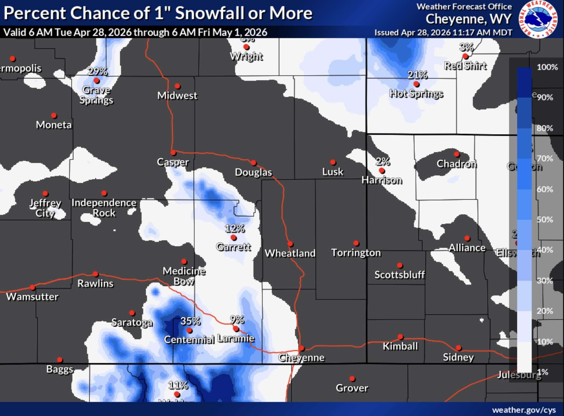
The image accompanying the forecast, sourced from the NWS Cheyenne, visually represents the expected snowfall distribution, highlighting the areas most likely to receive substantial accumulations. Another visual aid from the NWS depicts the percentage chance of receiving one inch or more of snowfall, further emphasizing the widespread nature of this winter weather event across the designated zones.
Safety Concerns and Travel Advisories
The National Weather Service has issued explicit warnings regarding the potential dangers of outdoor recreation during this period. Individuals engaged in activities such as hunting, hiking, or snowmobiling are strongly advised to exercise extreme caution. The combination of falling and blowing snow is expected to significantly reduce visibility, creating a high risk of disorientation and getting lost in backcountry areas. Unprepared individuals could find themselves in precarious situations due to the rapid onset of winter conditions.

Motorists traveling through the Sierra Madre and Snowy Range regions are urged to exercise prudence. Reduced visibility, slippery road surfaces due to snow accumulation, and the potential for drifting snow can create hazardous driving conditions. Drivers are advised to reduce their speed, increase following distances, and ensure their vehicles are equipped for winter travel. For real-time updates on road conditions, the NWS recommends utilizing the Wyoming Department of Transportation’s 511 service.
Background and Context: Late-Season Snowfall in Wyoming
While Wyoming is no stranger to winter weather, late-season snowfall of this magnitude in April can be notable. The Sierra Madre and Snowy Range are high-elevation mountain ranges that typically experience substantial snowfall throughout the winter months. However, the transition into spring often brings a mix of weather patterns, and significant snow events can still occur, particularly at higher altitudes.
The Sierra Madre Range, located in south-central Wyoming, is part of the larger Rocky Mountains and is known for its rugged terrain and significant snowpack. The Snowy Range, situated in southeastern Wyoming, is a popular destination for outdoor recreation and is also prone to heavy snowfall. Both ranges serve as vital headwaters for regional rivers and play a crucial role in the state’s water supply.
This specific weather event is occurring as many in the region might be anticipating warmer spring conditions. The NWS advisories are a critical reminder that winter weather can persist well into the spring in mountainous environments. The timing of this snowfall could impact early spring recreational activities and potentially influence the rate of snowmelt and its contribution to water resources.
Meteorological Factors
The precise meteorological factors driving this late-season snowfall would typically involve a strong low-pressure system interacting with cold air masses from the north. Such systems can draw moisture from significant distances, leading to widespread precipitation. In mountainous terrain, orographic lift—where air is forced upward by mountains, causing it to cool and condense—enhances snowfall. The specific trajectory and intensity of the storm system determine the amount of precipitation and its distribution. The NWS’s detailed forecast models would have been crucial in predicting the timing, intensity, and accumulation of this snowfall.
Potential Implications
The immediate implications of this snowfall are centered on public safety and travel. The reduction in visibility and potential for treacherous road conditions necessitate a heightened awareness for all individuals in the affected areas. For outdoor enthusiasts, the advisory serves as a critical reminder to check weather forecasts diligently, prepare for winter conditions even in spring, and consider postponing or altering plans if necessary.
From a broader perspective, this late-season snow event can have positive implications for water resources. The accumulated snowpack contributes to spring runoff, which is essential for agricultural irrigation, municipal water supplies, and ecosystem health throughout the summer months. While excessive accumulation can pose immediate risks, a healthy snowpack is generally beneficial for the region’s water security.
The event also highlights the dynamic and often unpredictable nature of mountain weather. The NWS plays a vital role in providing timely and accurate forecasts and advisories to help residents and visitors prepare for and mitigate the risks associated with such weather phenomena. The continuous monitoring and dissemination of weather information are paramount for ensuring public safety in areas prone to severe weather.
Official Statements and Public Preparedness
The National Weather Service’s issuance of the Winter Weather Advisory is a proactive measure aimed at informing the public and encouraging preparedness. Their communication strategy relies on clear, concise messaging about the expected conditions, potential hazards, and recommended safety precautions. By highlighting specific areas and potential impacts, the NWS empowers individuals to make informed decisions regarding their safety and travel plans.
While the provided content does not include direct quotes from local officials or residents, the issuance of such advisories typically prompts responses from emergency management agencies and transportation departments. These entities often reinforce the NWS warnings through their own communication channels, advising on road closures, preparedness tips, and emergency contact information. The emphasis on dialing 511 for road conditions underscores the collaborative effort to ensure public awareness and safety.
The advisory serves as a call to action for residents and visitors in affected areas to review their winter weather preparedness kits, ensure their vehicles are in good working order, and stay informed about changing conditions. The possibility of localized higher snow amounts underscores the need for vigilance, as conditions can vary significantly even within short distances in mountainous terrain.
This forecast for significant snowfall serves as a crucial reminder that spring in Wyoming’s high country is not always synonymous with mild weather. Preparedness, awareness, and adherence to safety guidelines are essential for navigating these late-season winter conditions.
