
The winter of 2024-2025 served as a stark reminder that a weak La Niña does not automatically guarantee the deep, mid-winter snowpacks that winter enthusiasts and water managers eagerly anticipate. This upcoming season, 2025-2026, presents a similarly nuanced forecast, prompting a closer examination of the El Niño-Southern Oscillation (ENSO) and other critical climate predictors that will shape the Pacific Northwest’s snow accumulation.
Understanding the El Niño-Southern Oscillation (ENSO)
The El Niño-Southern Oscillation (ENSO) is a naturally occurring climate phenomenon characterized by fluctuations in sea surface temperatures (SSTs) across the tropical Pacific Ocean. These shifts influence atmospheric circulation patterns, leading to significant impacts on weather systems globally. ENSO cycles through three primary phases: El Niño, characterized by warmer-than-average SSTs; La Niña, marked by cooler-than-average SSTs; and Neutral conditions, representing a state of balance.
Comparing ENSO Forecasts: 2024-2025 vs. 2025-2026
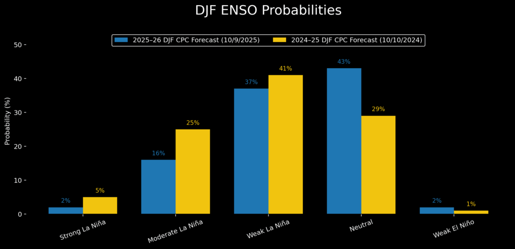
October forecasts for mid-winter ENSO probabilities reveal a striking similarity between the upcoming 2025-2026 season and the recently concluded 2024-2025 period. A subtle weakening of the La Niña signal is observed for the 2025-2026 season, though both forecasts indicate the highest probabilities for cool-phase conditions during the autumn and early winter months.
The Oceanic Niño Index (ONI), a primary metric for assessing ENSO, is derived from sea surface temperature departures from average in the Niño 3.4 region. For the 2024-2025 season, the December-January-February (DJF) ONI registered -0.6°C, barely placing it within the weak La Niña classification. Current weekly SST departures, also at -0.6°C, suggest that the 2025-2026 season is once again poised on the threshold of a weak La Niña. Mid-October Oceanic SST models project a November ONI minimum of approximately -0.8°C, with values expected to decrease to around -0.3°C by mid-winter (DJF). This trajectory makes neutral ENSO conditions the most probable outcome for the mid-winter snowpack in the Pacific Northwest.

Historical Snowpack Response to ENSO Phases
To understand the potential implications of the current ENSO forecast, it is crucial to examine how Pacific Northwest mountain snowpack has historically responded to different ENSO phases, utilizing an updated Snowpack Climatology Dataset.
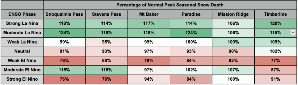
Weak La Niña Winters: In seasons characterized by weak La Niña conditions, most weather stations across the region typically experience snowpack levels near the historical average. Only a few specific locations, such as Mission Ridge and Timberline, have historically shown modest gains in snow depth during these periods.
Moderate and Strong La Niña Winters: These more robust La Niña events have consistently favored the western slopes and crests of the Cascade Mountains, resulting in peak snow depths that are significantly above normal, often ranging from 6% to 24% higher than average. These conditions are highly desirable for maximizing water reserves and providing ample recreational opportunities.
Neutral ENSO Years: Neutral ENSO phases generally lead to snowpack levels slightly below the regional average. While not as detrimental as El Niño conditions, they often signal a less bountiful winter in terms of snow accumulation.
El Niño Conditions: Conversely, most El Niño phases strongly correlate with reduced snowfall across the Pacific Northwest, increasing the likelihood of drier winters and diminished snowpack.
Analyzing the Probability Distribution for 2025-2026
The DJF ENSO probability distribution for the upcoming winter reveals that the long tails of the forecast hold significant influence on the mean prediction. There is an estimated 18% chance of a moderate to strong La Niña event and a mere 2% chance of an El Niño occurrence.
To refine the most likely outcomes, researchers have focused on the average snowpack data from four sites with the longest and most consistent historical records: Mt. Baker, Stevens Pass, Snoqualmie Pass, and Paradise. These locations provide a robust baseline for assessing regional snowpack trends.
Comparing Past Seasons and Future Projections
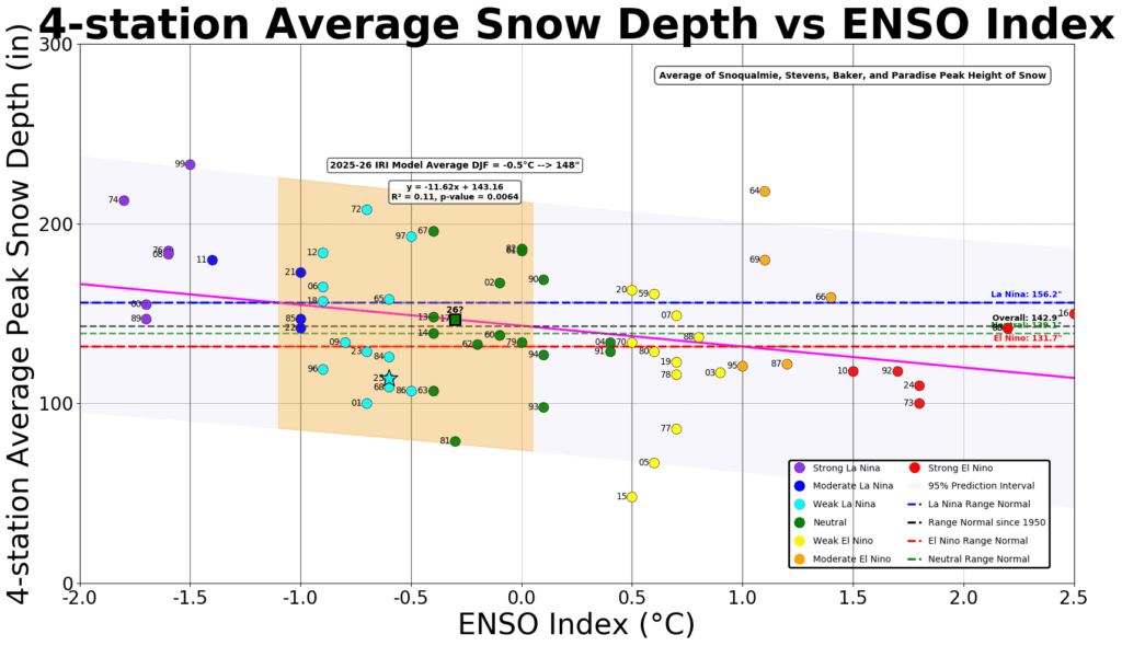
In the 2024-2025 season, the average peak snow depth was recorded at 114% of the historical average, falling within the 19th percentile for ENSO Index values between -1°C and 0°C. This was approximately 24% below the regression trendline, indicating a below-average snowpack, particularly at lower elevations, likely exacerbated by warmer temperatures.
To mitigate the influence of long-term climate trends, an analysis was conducted using only 21st-century data. This shortened dataset, while lowering the mean snow depth across all ENSO phases, still indicates that the ENSO forecast for the upcoming winter predicts an "almost perfectly average" winter.
The Limited Predictive Power of ENSO Alone
Linear best-fit trendlines explain only 11% of the data variability when considering the full 75-year ENSO vs. Snowpack dataset, and 19% when excluding 20th-century data. This underscores a critical point: over 80% of the year-to-year variability in snowpack is not explained by ENSO alone. This suggests that other atmospheric and oceanic factors play a substantial role in determining winter snow accumulation.
The Influence of Marine Heatwaves and Sea Surface Temperatures
Recent discussions have highlighted marine heatwaves in the Pacific, prompting an analysis of sea surface temperature (SST) anomalies. A comparison of SSTs from September and October 2025 against similar periods in 2024 and 2014 reveals that all three seasons exhibited mostly positive anomalies. While slightly positive anomalies have become increasingly common due to long-term climate shifts, the intensity and location of these warm anomalies warrant closer scrutiny.
The 2014-2015 season, despite a very weak El Niño, was characterized by anomalously warm SSTs just off the Pacific Northwest coast. Scientists have attributed a portion of the poor snow year in 2014-2015 to these warm waters, with the four-station average snowpack reading falling to less than 50% of the values observed in the 2024-2025 season.
While September 2025 began with notably warm SSTs across the Northeast Pacific, these waters have since cooled significantly. Crucially, the SSTs in the proximal waters off the coast are now approaching normal levels. This cooling trend is a positive development for potential snowpack accumulation.
Integrating ENSO with Regional Sea Surface Temperatures
A more comprehensive model that combines ENSO phase with proximal West Coast Marine waters (often referred to as "The Blob") can explain approximately 25% of the snowpack’s inter-seasonal variability. The potential for an eastward spread of exceptionally warm waters in the western North Pacific remains a factor to monitor.
The Role of the Pacific Decadal Oscillation (PDO)
The Pacific Decadal Oscillation (PDO) is another significant climate driver. As long as extraordinarily warm waters remain west of Hawaii, the region is likely to remain in the negative phase of the PDO. The State Climate Office has noted that a negative PDO phase correlates with cooler and snowier periods in the Pacific Northwest. An analysis of PDO versus ENSO phase explains approximately 20% of the snowpack variance, indicating its importance in modulating winter weather patterns.
Conclusion: A Forecast of Nuance and Uncertainty
The outlook for the 2025-2026 winter in the Pacific Northwest is one of considerable nuance and inherent uncertainty. There are no definitive predictors that can offer absolute certainty regarding snowpack depth. At best, approximately 25% of the variability in the 75-year snowpack dataset can be explained by combining ENSO and regional Sea Surface Temperatures.
The prevailing forecast suggests a weak La Niña is likely to transition into neutral conditions by mid-winter. This scenario portends a fairly typical snowpack for the region. The probability of a moderate or strong La Niña remains low, but if such an event were to materialize, it would significantly increase the likelihood of deeper snow accumulation.
Regional sea surface temperatures have shown a cooling trend, nearing normal levels. However, the presence of surrounding warmer waters could potentially limit further cooling. Therefore, the success of achieving deeper snowpacks will depend on a confluence of favorable factors: sustained upwelling off the coasts of South America and North America, continued cool-phase PDO conditions, and healthy marine ecosystems supporting robust fish populations. The coming months will be critical for observing these indicators and refining winter forecasts.
Disclaimers: This article is based on scientific projections and historical data. Actual winter conditions may vary.

