
Washington State, often recognized for its verdant landscapes and technological innovation, harbors a rich tapestry of geographical marvels and historical footnotes that extend far beyond common perception. From its unique ecological zones to its dramatic geological past and intriguing human history, the Evergreen State presents a compelling case study in the interplay of nature and human endeavor. A recent exploration by Geography By Geoff has brought to light 15 remarkable facts that underscore the state’s distinctive character, revealing a place of dramatic contrasts and surprising phenomena.
The Sole Temperate Rainforest in the Contiguous United States
One of Washington’s most striking geographical features is its status as home to the only temperate rainforest within the contiguous United States. Located primarily on the Olympic Peninsula, this unique ecosystem thrives due to the potent influence of Pacific air currents. As these moisture-laden winds encounter the imposing Olympic Mountains, they are forced upward, triggering heavy precipitation. Annually, certain areas on the peninsula can receive upwards of 12 feet of rain, fostering an environment characterized by towering ancient trees, lush undergrowth, and a rich biodiversity unlike anything found elsewhere in the lower 48 states. This phenomenon is a testament to the powerful influence of topography on climate and ecological development.
Echoes of Ice Age Cataclysms: The Missoula Floods
The dramatic landscape of Eastern Washington bears indelible scars from a series of cataclysmic events during the last ice age. Geologists have meticulously documented the impact of the Missoula Floods, a series of immense glacial lake outbursts that reshaped the region. Approximately 15,000 years ago, a massive ice dam on the Clark Fork River in Montana repeatedly failed, unleashing colossal walls of water that surged across Eastern Washington. These floods, estimated to have been hundreds of feet high, carved out the distinctive Channeled Scablands, a vast area of eroded basalt. A particularly striking remnant of this era is Dry Falls, a colossal waterfall system that, at its peak, was five times the width of Niagara Falls, serving as a powerful reminder of the Earth’s geological dynamism.
Cape Flattery: The Westernmost Reach of the Lower 48
Contrary to common assumptions that California or Oregon might hold this distinction, the westernmost point of the contiguous United States is actually Cape Flattery, located on the northwestern tip of Washington State. This dramatic promontory juts out into the Pacific Ocean, offering breathtaking views and a rugged coastline. Access to Cape Flattery requires a moderate, approximately three-mile hike through coastal forests, rewarding intrepid visitors with stunning vistas and a tangible sense of America’s western edge. The geographical positioning of Cape Flattery is a direct consequence of the westward expansion and the geopolitical agreements that defined the nation’s boundaries.
Mount Rainier: A Majestic Volcano with Dormant Power
Mount Rainier, an iconic stratovolcano and the highest peak in the Cascade Range, holds a significant geological and ecological position. It is estimated to contain more glacial ice than all other Cascade volcanoes combined, a staggering volume of frozen water that contributes to the state’s hydrological systems. However, this majestic presence is also a source of potential peril. As an active volcano, a significant eruption could trigger a catastrophic lahar—a volcanic mudflow—that would descend into the densely populated valleys below, posing a severe threat to communities and infrastructure. The monitoring and preparedness efforts surrounding Mount Rainier are critical components of the region’s disaster management strategy.
The Cascades’ Fiery Heart: A Ring of Fire Hotspot
Washington State lies squarely within the Pacific Ring of Fire, a horseshoe-shaped zone of intense seismic and volcanic activity. The state is home to five active volcanoes, all formed by the subduction of the Juan de Fuca tectonic plate beneath the North American plate. The most infamous of these is Mount St. Helens, whose cataclysmic eruption on May 18, 1980, dramatically reshaped the landscape. The eruption reduced the mountain’s summit by approximately 1,300 feet and devastated hundreds of square miles of forest through pyroclastic flows and lahars. The ongoing volcanic activity in the region underscores the dynamic geological forces at play.
Point Roberts: An Accidental American Enclave
The geopolitical landscape of Washington State includes a peculiar anomaly: the community of Point Roberts. This American exclave, situated on the tip of a peninsula, was inadvertently created by the 1846 Oregon Treaty. The treaty established the 49th parallel as the boundary between the United States and British North America (now Canada). However, due to inaccuracies in cartography at the time, the defined border sliced off the southernmost portion of the peninsula, leaving it geographically isolated from the rest of the United States. Residents of Point Roberts must traverse Canadian territory to reach the mainland United States by land, a unique commuting experience that highlights the sometimes arbitrary nature of political borders.
The Pig War: A Bloodless Standoff Over a Swine
A fascinating chapter in U.S.-British relations, the San Juan Islands border dispute, often referred to as the "Pig War," is a testament to how seemingly minor incidents can escalate into international tensions. The conflict, which spanned 12 years from 1859 to 1871, was triggered by a rather unusual event: an American farmer, Lyman Cutlar, shot a British Hudson’s Bay Company pig. The pig had a habit of rooting through Cutlar’s potato patch. The pig’s owner demanded compensation, and the incident quickly escalated into a territorial standoff involving both American and British military forces. Fortunately, the only casualty of this protracted dispute was the pig itself, with the matter ultimately resolved through arbitration.
Seattle’s Subterranean Legacy: The Underground City
Following the Great Seattle Fire of 1889, a devastating inferno that consumed much of the city’s downtown core, Seattle embarked on an ambitious rebuilding effort. To combat persistent problems with tidal flooding and to create a more stable foundation, city planners decided to raise the street level by an average of 12 to 30 feet. This ambitious undertaking resulted in the original ground floors of many buildings being buried, creating an extensive network of subterranean corridors and spaces. Today, these remnants of old Seattle exist as a unique underground city, offering a glimpse into the city’s past and serving as a popular tourist attraction.
The Hanford Site: A Nuclear Legacy and Cleanup Challenge
The remote desert landscape of Eastern Washington played a critical role in the Manhattan Project during World War II. The Hanford Site was chosen for its strategic advantages: the abundant water from the Columbia River, the power provided by the Grand Coulee Dam, and the isolation offered by the arid environment. These factors were deemed essential for the production of plutonium, a key component in the development of atomic weapons. While the site fulfilled its wartime mission, it left behind a complex and challenging legacy. Today, Hanford is considered the most contaminated nuclear cleanup site in the Western Hemisphere, a monumental undertaking involving the safe management and disposal of radioactive materials. The ongoing efforts at Hanford represent one of the largest environmental remediation projects in the world.
A Naming Convention’s Unintended Consequence
The naming of Washington Territory in 1853 is a curious tale of geographical nomenclature. A congressman, seeking to avoid confusion with the District of Columbia, proposed blocking the name "Columbia" for the new territory. In its place, the territory was named Washington, in honor of George Washington. Ironically, this decision created precisely the kind of naming confusion the congressman had sought to prevent, leading to persistent ambiguity between the state of Washington and the nation’s capital. This historical anecdote highlights the sometimes-unforeseen consequences of legislative decisions.

The Marvel of Floating Bridges: Engineering for Puget Sound
The complex geography of Puget Sound, characterized by its numerous islands, peninsulas, and deep, soft lakebeds, presents significant challenges for traditional bridge construction. Lake Washington, a large freshwater lake near Seattle, proved particularly difficult to bridge due to its deep and unstable bottom. To overcome these obstacles, engineers developed an innovative solution: floating bridges. These remarkable structures are built on massive concrete pontoons that rest on the water’s surface, allowing them to span the lake. Washington State is now home to four of the five longest floating bridges in the world, a testament to its pioneering spirit in civil engineering.
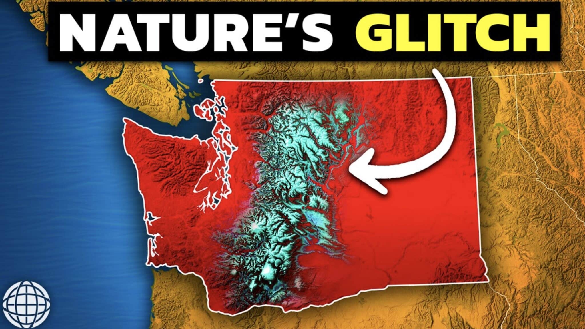
The Cascade Curtain: A Divide of Worlds
The imposing Cascade Mountain Range acts as a formidable geographical and climatic divider within Washington State, effectively creating two distinct regions. To the west lies a realm of abundant rainfall, lush evergreen forests, and a densely populated, technologically advanced urban landscape, epitomized by Seattle. This side of the Cascades benefits from the moderating influence of the Pacific Ocean. In stark contrast, the eastern side of the range exists in the mountains’ rain shadow, resulting in a drier, more arid climate. This region is characterized by less population density, a reliance on agriculture, and a landscape that often resembles a high desert. This "Cascade Curtain" profoundly influences the climate, economy, and culture of the state.
The Grand Coulee Dam: Powering a Region
The Grand Coulee Dam, a colossal engineering feat on the Columbia River, stands as the largest power-producing facility in the United States. Completed in stages over several decades, the dam’s immense hydroelectric power output has been instrumental in the development of the Pacific Northwest. Its cheap and abundant electricity fueled the growth of industries such as aluminum smelting and played a vital role in supporting Boeing’s wartime production efforts. Beyond its power generation capabilities, the dam’s associated irrigation systems have transformed over 600,000 acres of formerly arid land in Eastern Washington into productive farmland, fundamentally altering the agricultural landscape of the region.
Washington: The Unsung Apple Capital
While the western part of Washington is renowned for its rain, the state’s reputation as the "Apple Capital of the World" stems from its dry, eastern desert regions. Farmers in areas like the Wenatchee Valley have successfully cultivated apples by harnessing the waters of the Columbia River. The volcanic soil, combined with approximately 300 days of sunshine annually, provides ideal conditions for apple cultivation. Washington State produces roughly 60% of all apples grown in the United States, a significant agricultural achievement that belies its association with rainy weather.
The Nation’s Largest Ferry System: Navigating Puget Sound’s Intricacies
The intricate network of islands, peninsulas, and glacier-carved fjords that define Puget Sound makes traditional highway infrastructure challenging and, in many areas, impossible. To facilitate transportation and connectivity, Washington State has developed the largest ferry system in the United States. This vital network carries over 20 million passengers and 10 million vehicles annually, connecting communities and providing essential services across the sound. The Washington State Ferry system is not merely a mode of transport; it is an integral part of the state’s infrastructure and a symbol of its adaptation to its unique maritime geography.
The collective impact of these fifteen facts reveals Washington State as a place of extraordinary geographical diversity and historical significance. From the ancient forces that shaped its land to the human ingenuity that has adapted to its challenges, the Evergreen State continues to offer a compelling narrative of natural wonder and human endeavor. The ongoing exploration of its unique attributes, as highlighted by Geography By Geoff, serves to deepen our appreciation for the complex and captivating character of this Pacific Northwest gem.
