
The winter of 2024-2025 served as a stark reminder that a weak La Niña does not automatically guarantee the deep, mid-winter snowpacks that winter enthusiasts and water resource managers eagerly anticipate. This past season’s performance highlighted the complex interplay of atmospheric and oceanic drivers that shape regional weather patterns, prompting a closer examination of the forthcoming winter of 2025-2026. Forecasters are once again turning their attention to the El Niño-Southern Oscillation (ENSO), a critical climate phenomenon that influences global weather. Understanding how ENSO phases typically correlate with snowpack accumulation in the Pacific Northwest is paramount for predicting the upcoming season’s conditions and their subsequent impacts.
Understanding the El Niño-Southern Oscillation (ENSO)
ENSO is a naturally occurring, cyclical fluctuation in sea surface temperatures (SSTs) across the equatorial Pacific Ocean. This phenomenon alternates between three distinct phases: El Niño, characterized by warmer-than-average SSTs; La Niña, defined by cooler-than-average SSTs; and Neutral, where conditions are closer to the long-term average. These phases have a profound influence on atmospheric circulation patterns, affecting precipitation, temperature, and storm tracks worldwide, including the crucial weather systems that deliver snow to the mountains of the Pacific Northwest.
The primary metric for monitoring ENSO is the Oceanic Niño Index (ONI), which tracks SST departures from the average in the Niño 3.4 region of the Pacific. A sustained ONI value above +0.5°C indicates El Niño, while a value below -0.5°C signifies La Niña. The period between December and February (DJF) is often considered the core of the winter season, making the ONI during these months particularly relevant for assessing snowpack potential.
Comparing ENSO Forecasts: 2024-2025 vs. 2025-2026
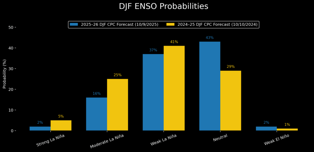
A comparative analysis of October forecasts for mid-winter ENSO probabilities reveals striking similarities between the upcoming 2025-2026 season and the recently concluded 2024-2025 season. Both forecasts indicate a strong likelihood of cool-phase conditions, specifically La Niña, during the autumn and early winter months. However, there is a subtle but significant weakening of the La Niña signal projected for 2025-2026 when compared to the previous year’s forecast.

During the winter of 2024-2025, the DJF ONI registered -0.6°C, which narrowly placed it within the weak La Niña category. Looking ahead to the 2025-2026 winter, current weekly SST departures also hover around -0.6°C, suggesting a similar trajectory towards a weak La Niña. Mid-October Oceanic SST models from the National Oceanic and Atmospheric Administration’s Climate Prediction Center (CPC) projected a November minimum ONI of approximately -0.8°C. These models anticipate a decrease in these values to around -0.3°C by midwinter (DJF). This trend indicates that neutral ENSO conditions are the most probable outcome for the mid-winter period of 2025-2026. While a weak La Niña may manifest in the early part of the season, its influence is expected to wane as winter progresses, shifting the balance towards neutral conditions.
Historical Snowpack Response to ENSO Phases
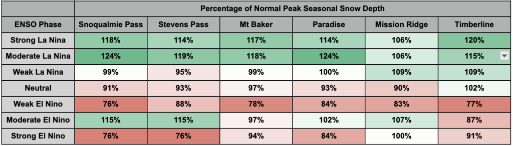
To understand the potential implications of these ENSO projections, it is essential to examine how Pacific Northwest mountain snowpacks have historically responded to different ENSO phases. An updated Snowpack Climatology Dataset, compiled from various weather stations across the Cascade Mountains, provides valuable insights.
- Weak La Niña Winters: In past weak La Niña winters, most monitoring stations typically recorded snowpack levels close to the historical average. Some locations, such as Mission Ridge and Timberline, have shown modest increases in snow depth, but these gains have not been widespread or substantial enough to define a consistently snowy pattern.
- Moderate and Strong La Niña Winters: The most significant positive impacts on snowpack are observed during moderate and strong La Niña years. These conditions consistently favor the western slopes and crest of the Cascade Mountains, leading to peak snow depths that are statistically higher than normal, often ranging from 6% to 24% above average. These stronger La Niña events are crucial for building deep, resilient snow reservoirs.
- Neutral ENSO Years: Neutral ENSO conditions generally correlate with slightly below-average snowpack across the region. While not as detrimental as El Niño, neutral phases tend to produce less abundant snowfall compared to strong La Niña events, requiring careful management of water resources.
- El Niño Winters: El Niño conditions overwhelmingly tilt the odds towards reduced snowfall. The warmer SSTs associated with El Niño often lead to atmospheric patterns that draw moisture away from the Pacific Northwest or bring warmer, wetter air that results in more rain at lower elevations and less snow at higher elevations.
Analyzing the 2025-2026 Snowpack Forecast: A Closer Look
The probability distributions for the DJF ENSO phases for the upcoming winter show a 70% chance of neutral conditions, a 18% chance of a moderate to strong La Niña, and a mere 2% chance of El Niño. These long tails in the probability distribution highlight the influence of the less likely but potentially impactful scenarios.
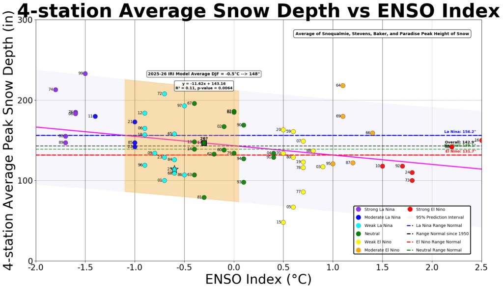
To provide a more refined outlook, an analysis was conducted using the average of four sites with the longest and most robust historical data records: Mt. Baker, Stevens Pass, Snoqualmie Pass, and Paradise. This focused analysis helps mitigate the influence of shorter data sets or localized anomalies.
In the 2024-2025 season, the average peak snow depth at these four key locations was approximately 114% of the historical average, placing it around the 19th percentile for ENSO Index values between -1°C and 0°C. This figure was notably 24% below the regression trendline, indicating a less-than-ideal snowpack, particularly at lower elevations where warmer temperatures contributed to more precipitation falling as rain.
To account for potential long-term climate trends that might skew historical comparisons, the analysis was also performed using only 21st-century data. This shortened dataset, while reducing the overall mean snow depth across all ENSO phases, still yielded a similar overarching conclusion. Even with this more recent data, the ENSO forecast for the 2025-2026 winter predicts an "average" winter in terms of snowpack accumulation.
Beyond ENSO: The Role of Regional Sea Surface Temperatures
While ENSO is a primary driver of inter-seasonal variability in snowpack, it does not tell the entire story. Linear regression analyses indicate that ENSO alone explains only 11% to 19% of the data variability in snowpack, meaning over 80% of the season-to-season variation remains unexplained by this single factor. This underscores the importance of considering other influential climate drivers.
The presence of marine heatwaves, such as the one observed in September of the 2024-2025 season, warrants attention. A comparative analysis of SSTs from September and October in 2025 against similar periods in 2024 and 2014 reveals the dynamic nature of ocean temperatures. While slightly positive SST anomalies have become more common due to long-term climate warming, the intensity and location of these anomalies are critical. The 2014-2015 season, for instance, experienced a very weak El Niño but was characterized by anomalously warm SSTs just off the Pacific Northwest coast. Scientists partially attributed the poor snow year of 2014-2015 to these localized warm waters, with the four-station average snowpack reading falling to less than 50% of the values observed in the 2024-2025 season.
The Pacific Decadal Oscillation (PDO) and its Influence
The interplay between ENSO and regional SSTs, particularly off the West Coast of North America (often referred to as "The Blob"), can explain approximately 25% of the snowpack’s inter-seasonal variability. The eastward spread of exceptionally warm waters in the western North Pacific is a key factor to monitor. As long as these anomalously warm waters remain west of Hawaii, the Pacific Northwest is likely to remain in the negative phase of the Pacific Decadal Oscillation (PDO).
The PDO is a long-term climate pattern characterized by shifts in the sea surface temperature and atmospheric pressure across the North Pacific Ocean. A negative PDO phase, according to observations from the State Climate Office, typically correlates with cooler and snowier periods in the Pacific Northwest. This contrasts with a positive PDO phase, which can exacerbate warming trends. An analysis combining PDO and ENSO phases explains approximately 20% of the snowpack variance, demonstrating the additive influence of these large-scale climate drivers.
Implications and Outlook for Winter 2025-2026
The outlook for the 2025-2026 winter in the Pacific Northwest suggests a season that is likely to be characterized by near-normal snowpack accumulation. The projected weak La Niña is expected to transition into neutral ENSO conditions by mid-winter. While a moderate or strong La Niña remains a low-probability event, its occurrence would significantly improve the chances of deeper snowpacks.
Regional sea surface temperatures have shown a cooling trend, moving closer to normal levels. However, the presence of surrounding warmer ocean waters may limit the potential for further significant cooling, which could otherwise enhance snowfall. This suggests that while conditions are not strongly leaning towards a deficit, they are also not signaling an exceptionally snowy winter.
The limited explanatory power of ENSO and regional SSTs (around 25%) on snowpack variability highlights the inherent uncertainty in long-range forecasting. Over 75% of the year-to-year snowpack variation is influenced by factors not fully captured by these models, including atmospheric river activity, storm track intensity, and localized weather phenomena.
Looking Ahead: Factors to Monitor
For winter enthusiasts, resource managers, and the general public, the following factors will be crucial to monitor as the season progresses:
- Sustained Upwelling: Continued upwelling of cold, nutrient-rich water off the coasts of South America and North America is a positive indicator for cooler ocean temperatures and potentially more favorable snow conditions.
- PDO Phase: The persistence of a negative PDO phase is critical for promoting cooler and snowier periods in the region. Any shift towards a positive PDO could counteract beneficial ENSO signals.
- Marine Ecosystem Health: The abundance of marine life, such as sardines and salmon, is often an indicator of healthy ocean conditions that can indirectly influence weather patterns.
In conclusion, the winter of 2025-2026 in the Pacific Northwest is poised to be a season of moderate expectations. While a weak La Niña may offer a slight advantage early on, the prevailing forecast points towards neutral ENSO conditions and a typical snowpack. The scientific community will be closely watching for any deviations from these projections, as the complex dance of global climate phenomena continues to shape the winter landscape of the region.
Disclaimers:
This analysis is based on current scientific understanding and forecast models. Climate patterns are dynamic and subject to change. The information provided is for informational purposes and should not be considered a definitive prediction.
