
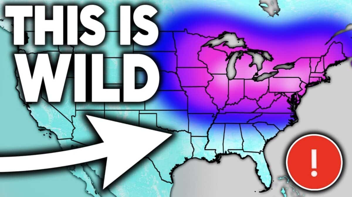
The eastern United States is bracing for an extended period of unseasonably cold weather, with forecasts indicating that below-normal temperatures will persist through at least the first half of June. This unusual late-spring chill is attributed to a rare backdoor arctic flow originating from eastern Canada, a phenomenon that meteorologists note is atypical for this time of year. The persistent cold is expected to hold through approximately June 10th to 12th, though brief periods of warmer weather are interspersed within the first week of the month.
Atypical Cold Front Grips the East Coast
Meteorologists at Direct Weather have highlighted the unusual nature of this late-season cold snap. Typically, by early June, warmer air masses have firmly established themselves across much of the eastern seaboard. However, a potent arctic air mass is currently pushing south from eastern Canada, creating a persistent "backdoor" cold front. This pattern is characterized by northerly winds that bring frigid air masses into regions that would normally be experiencing spring-like or early summer conditions. The National Oceanic and Atmospheric Administration (NOAA) defines a backdoor cold front as one that moves into the eastern United States from the northeast or east, rather than the more common west-to-east progression. Such events can significantly disrupt local weather patterns and impact agricultural planning.
The prolonged nature of this cold spell is particularly noteworthy. While isolated cold fronts are common, a sustained pattern of this magnitude extending into the second week of June is an anomaly. Data from meteorological archives indicates that such persistent cold in early June is infrequent, with previous occurrences often linked to specific atmospheric teleconnections that favor the southward intrusion of polar air. The implications for early summer activities, such as outdoor events and agriculture, are significant, with potential delays in planting seasons and increased energy demand for heating in some areas.
Stormy Skies Loom for the Central United States
While the East Coast grapples with unseasonable cold, the central United States is facing an active weather pattern with a heightened risk of severe thunderstorms. Direct Weather’s forecast identifies Texas, Oklahoma, and Kansas as areas with a significant probability of severe weather events on Wednesday, June 4th, and Thursday, June 5th. These storms could bring with them the threats of damaging winds, large hail, and isolated tornadoes, as is common during this time of year in the Plains.
By the weekend, the storm threat is projected to expand eastward. Thunderstorm activity is expected to spread into the Ohio Valley, the Mid-Atlantic region, and the Northeast. This widespread precipitation could provide much-needed moisture to drought-stricken areas, but also carries the potential for flash flooding in regions that receive heavy rainfall. Precipitation totals over the next two weeks are forecast to be above average across the southeastern and central parts of the country, indicating a potentially wet period for a large swathe of the nation.
The juxtaposition of unseasonable cold in the East and active storm systems in the Central U.S. highlights the complex and sometimes contradictory nature of weather patterns. This can be influenced by a variety of atmospheric drivers, including jet stream positioning and the presence of moisture-laden air masses.

A Potentially Historic El Niño on the Horizon
Perhaps the most significant and far-reaching forecast element from Direct Weather’s update concerns the developing El Niño phenomenon. Emerging data from the Climate Prediction Center’s (CPC) Climate Forecast System version 2 (CFSV2) model paints a stark picture: every single ensemble member of the model is projecting this developing El Niño to surpass the strength of the strongest El Niño ever recorded by October or November of this year.
The previous record for El Niño intensity was established during the 1997-1998 event, which saw sea surface temperatures in the central Pacific Ocean reach approximately 2.6 to 2.8 degrees Celsius above average. The current CFSV2 model mean is tracking a staggering 3.7 to 3.8 degrees Celsius above average, a level of warmth that has never been observed in the historical record. This projected magnitude of warming in the Pacific is unprecedented and carries profound implications for global weather patterns.
Understanding El Niño and Its Potential Impact
El Niño is a climate pattern characterized by the unusual warming of surface waters in the eastern tropical Pacific Ocean. This warming disrupts atmospheric circulation patterns across the globe, leading to a wide range of weather anomalies. Typically, El Niño events influence:
- Precipitation Patterns: Many regions experience increased rainfall, while others face drought conditions. For instance, the southern United States often sees wetter winters during El Niño, while the Pacific Northwest can experience drier conditions.
- Temperature Anomalies: Global average temperatures tend to rise during El Niño years. Specific regional temperature impacts vary.
- Tropical Cyclone Activity: El Niño tends to suppress hurricane activity in the Atlantic basin due to increased wind shear, while potentially enhancing it in the eastern North Pacific.
- Seasonal Weather Patterns: The effects of El Niño can extend throughout the year, influencing summer heatwaves, autumn storm tracks, and winter cold spells in various parts of the world.
The projected strength of this incoming El Niño is so significant that its downstream effects are difficult to predict with certainty, as there is no historical precedent for an event of this magnitude. Scientists are closely monitoring the situation, as such a powerful El Niño could lead to extreme weather events across the globe.
Analysis of Implications
The combination of unseasonable cold in the Eastern U.S. and the looming prospect of a historic El Niño creates a complex meteorological landscape. The immediate concern is the impact of the persistent cold on agriculture and outdoor industries. Farmers may face delays in planting, potentially affecting crop yields for the season. Ski resorts that might have hoped for late-season snow are likely to be disappointed.
The broader implications of a record-breaking El Niño are vast and multifaceted. The potential for intensified global weather extremes is a primary concern. This could manifest as more severe droughts in some regions, increased flooding in others, and significant shifts in storm tracks.
Hurricane Season Concerns: The typical Atlantic hurricane season, which officially begins on June 1st, could be significantly impacted. While El Niño generally suppresses Atlantic hurricane activity, the sheer potential strength of this event adds a layer of uncertainty. Some models suggest that while the number of storms might be reduced, the intensity of any storms that do form could be amplified by warmer ocean waters.
Global Weather Systems: The disruption to global atmospheric circulation could lead to unusual weather patterns far beyond North America. Regions that typically experience certain weather phenomena might see their patterns altered dramatically. This necessitates a global perspective in forecasting and disaster preparedness.
Economic and Societal Impacts: Extreme weather events, whether droughts, floods, or heatwaves, have significant economic and societal consequences. Impacts on agriculture, energy infrastructure, water resources, and public health are all potential outcomes that require careful consideration and planning.
Official Responses and Monitoring
Organizations such as NOAA and its sub-agencies, including the Climate Prediction Center (CPC), are at the forefront of monitoring and forecasting these climate patterns. The CPC regularly issues outlooks and advisories on El Niño and La Niña conditions, as well as other climate drivers. The data from models like the CFSV2 are crucial for informing these assessments.
Meteorologists and climate scientists emphasize the importance of continued observation and refinement of forecast models as the El Niño develops. While the current projections are concerning, the exact timing and magnitude of its impacts will become clearer as more data becomes available. International meteorological organizations are also coordinating efforts to track and predict the global ramifications of such a significant climate anomaly.
Looking Ahead
The coming months will be critical for understanding the full scope of the developing weather patterns. The persistence of cold air in the East, coupled with the potential for a record-breaking El Niño, presents a unique challenge for forecasters and a significant variable for planning across numerous sectors. As the Northern Hemisphere transitions into summer, the interplay between these atmospheric forces will be closely watched, with the potential for widespread and impactful weather events across the globe. The scientific community’s ability to refine its predictions and communicate these complex patterns effectively will be paramount in helping communities prepare for the challenges ahead.
