
Skiers and snowboarders across the Northwest are being advised to prepare for a 2026-27 winter season characterized by warmer, drier, and more variable conditions. The anticipated strengthening of El Niño is projected to diminish the likelihood of the classic deep mid-winter powder dumps in Idaho, Oregon, and Washington. Meanwhile, Alaska is likely to experience a distinct pattern, with a potentially stormy fall followed by a milder, though not necessarily snow-deficient, winter. This forecast, grounded in the latest climate predictions from NOAA’s Climate Prediction Center, signals a significant departure from the snow-favored conditions often associated with its counterpart, La Niña.
El Niño 2026-27: Setting the Stage for a Shifted Climate Pattern
The scientific consensus, as articulated by NOAA’s Climate Prediction Center (CPC), confirms the formation of an El Niño event in the Pacific Ocean. This oceanic phenomenon, marked by warmer-than-average sea surface temperatures across the central and eastern equatorial Pacific, is expected to intensify throughout the latter half of 2026. Forecasters indicate a high probability of a very strong El Niño by the critical winter months of November through January.
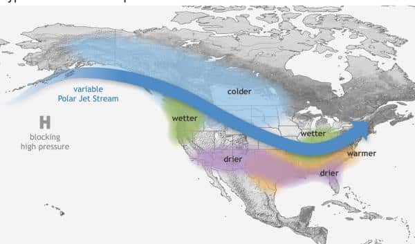
The influence of El Niño extends far beyond oceanic temperatures, fundamentally altering global atmospheric circulation patterns. Specifically, it typically redirects the jet stream, steering storm tracks southward. This often results in a convergence of cooler and stormier weather across the southern United States, while simultaneously promoting warmer and drier conditions across much of the northern tier of North America. For the ski industry in the Pacific Northwest, this broad atmospheric shift translates into a direct impact on snowfall. The typical trajectory of winter storms is altered, leading to fewer cold systems penetrating the region and an increased likelihood of precipitation falling as rain at lower and mid-elevations, thereby compromising snow accumulation.
Timeline of El Niño Development and Forecast:
- Spring/Summer 2026: Initial signs of warming sea surface temperatures in the equatorial Pacific emerge.
- Late Summer/Early Fall 2026: El Niño conditions are confirmed and begin to strengthen. NOAA issues advisories to meteorological agencies and the public.
- November 2026: El Niño is expected to be well-established, influencing weather patterns across North America.
- December 2026 – January 2027: Peak intensity of the El Niño event is forecast, with the highest probability of its characteristic impacts on regional climates.
- February – April 2027: El Niño conditions are expected to persist, with forecasts indicating a gradual weakening as spring progresses.
What Northwest Riders Can Expect: Idaho, Oregon, and Washington
For the states of Idaho, Oregon, and Washington, regions traditionally blessed with abundant snowfall, the El Niño forecast presents a cause for careful planning. Historical data and climate modeling consistently show that El Niño episodes correlate with warmer and drier autumns and winters in these areas. A key characteristic of these seasons is a greater proportion of precipitation falling as rain rather than snow, especially at lower and middle elevations, which are crucial for ski resort operations.
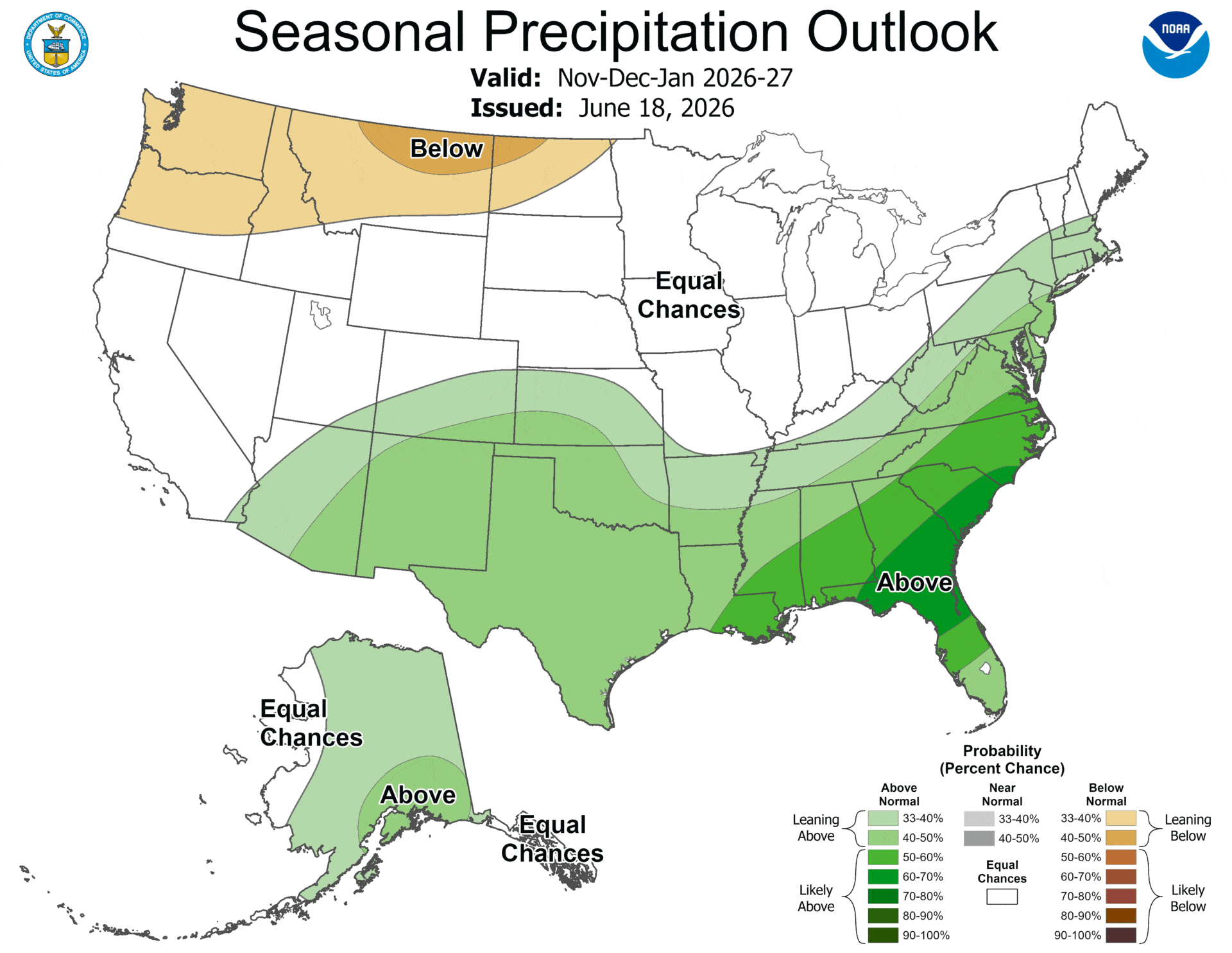
NOAA’s seasonal outlook for November 2026 through January 2027 specifically highlights an increased probability of below-normal precipitation across significant portions of these states. This directly translates to expectations of reduced overall snow accumulation. Skiers and snowboarders should anticipate a potentially thinner snow base early in the season, more frequent and pronounced mid-winter melt-freeze cycles, and a snowpack that may accumulate in intermittent bursts rather than sustained, deep accumulations.
The nature of snowfall is also likely to change. Instead of the consistent "cold smoke" events that define classic Northwest powder days, riders may encounter a more varied mix of storm types. This could include periods of wet snow, heavy, moisture-laden powder, and transitions to rain, particularly at lower elevations. The implications for travel planning are significant: the traditional approach of banking on a consistently snowy pattern may need to be replaced by a more dynamic strategy of flexibility and responsiveness to short-term weather windows. Chasing individual colder systems, which may be fewer and farther between, will likely become a more common tactic for those seeking optimal snow conditions.
Analysis of Snowpack Implications:
- Reduced Snow Depth: Lower overall precipitation and a higher rain-to-snow ratio will likely result in diminished snowpack depth at many resorts.
- Increased Freeze-Thaw Cycles: Warmer temperatures and intermittent precipitation will lead to more frequent cycles of thawing and refreezing, creating icy conditions and hard crusts.
- Variable Snow Quality: Riders may experience a wider range of snow conditions, from soft powder at high elevations to heavy, wet snow or even rain at lower elevations.
- Delayed Season Openings: Resorts at lower elevations or with less natural snowfall may face challenges in opening on time or maintaining consistent operations throughout the season.
Alaska: A Tale of Two Seasons
Alaska’s response to El Niño conditions typically diverges from the contiguous Northwest, presenting a unique set of expectations for its winter sports enthusiasts. Past El Niño events have often ushered in wetter autumns with an increased frequency of storms, particularly along the Gulf of Alaska. Simultaneously, winter conditions in Alaska under El Niño tend to be somewhat warmer and, paradoxically, can sometimes be drier overall compared to La Niña years.
NOAA’s seasonal outlook for November 2026 through January 2027 supports this nuanced view, indicating elevated odds of above-normal precipitation across much of Alaska, coupled with generally higher temperatures. This suggests a potentially active shoulder season, with coastal and maritime-influenced mountain ranges likely to experience a stormy fall, bringing substantial early snowfall to higher elevations. However, the increased likelihood of warm air intrusions means that snow quality can be variable, with occasional rain events impacting lower slopes.
As winter progresses, the combination of relative warmth and drier conditions could lead to extended periods of high-pressure systems. These high-pressure events are known for producing firm surfaces, icy crusts, and, on sun-exposed aspects, mid-winter corn snow. Backcountry travelers in Alaska’s high latitudes will need to remain particularly vigilant. Complex weak layers can form when warm storms deposit snow over older, faceted snowpack, which is then followed by dry, cold spells. This layering can create persistent avalanche hazards. Therefore, Alaskan skiers and riders might experience a front-loaded season in certain regions, with good early snow, followed by longer periods of stable but less frequently refreshed snow conditions.
Key Considerations for Alaska:
- Stormy Fall Potential: Expect a higher chance of significant snowfall in the fall, especially in coastal areas.
- Milder Winter Temperatures: Winter temperatures are likely to be above average, impacting snowpack stability and consistency.
- Variable Snow Quality: Rain events and freeze-thaw cycles can create challenging snow conditions.
- Avalanche Hazard Awareness: Complex snowpack structures due to alternating warm and cold spells require heightened attention to avalanche safety.
Snowpack, Runoff, and Backcountry Hazards: A Deeper Dive
The implications of an El Niño winter extend beyond the ski resorts and into the broader environmental context, particularly concerning snowpack structure, water resources, and backcountry safety. In Idaho, Oregon, and Washington, the tendency for reduced snow accumulation and a higher incidence of rain-driven precipitation during El Niño years can significantly influence the snowpack’s internal structure.
Warmer and drier winters typically result in less total snow and more pronounced mid-winter melt events. These melt events are critical in forming distinct layers within the snowpack, such as hard crusts and rain layers. These interfaces can become zones of weakness, contributing to complex avalanche scenarios that may persist longer and evolve in unpredictable ways compared to the more straightforward snowpack development often seen in colder, snowier La Niña winters. Backcountry skiers and splitboarders must therefore exercise extreme caution, carefully assessing snowpack conditions and potential avalanche hazards.
Furthermore, a diminished snowpack directly impacts spring runoff and summer water availability. Reduced snowmelt means lower water levels in rivers and streams, which has significant consequences for ecosystems, including salmon populations, and for human water needs. For outdoor recreationists, this can translate to a shortened window for safe, continuous snow travel in the spring. Exposed ground and mixed travel surfaces may become more prevalent earlier in the season, altering the typical patterns of late-spring backcountry touring.
Looking Beyond One Season: Long-Term Trends and Adaptability
The cyclical nature of El Niño and La Niña events is a well-established aspect of Earth’s climate system. However, emerging climate projections suggest a potential intensification of these cycles. Some climate models indicate the possibility of more frequent and intense El Niño and La Niña events in the coming decades. This would likely lead to more pronounced swings between extreme boom and bust seasons in regional ski climates, necessitating greater adaptability from the ski industry and its patrons.
For the upcoming 2026-27 El Niño season, the overarching takeaway for skiers and snowboarders in the Northwest is to anticipate a winter that leans towards warmth and variability. While parts of Alaska may offer better odds of consistent early-season storms, Idaho, Oregon, and Washington are more likely to experience elevation-dependent snow conditions and a more unpredictable season.
It is crucial to remember that El Niño, like any climate driver, tilts the odds rather than dictating absolute outcomes. Local mountain microclimates can and often do defy regional patterns for significant periods. Therefore, the most prudent approach for skiers and riders is to remain informed, consistently track NOAA’s outlooks throughout the winter, pay close attention to freezing level forecasts, and maintain flexibility in their travel plans and destination choices. By embracing adaptability and staying abreast of evolving weather patterns, winter sports enthusiasts can maximize their chances of enjoying the season, regardless of the prevailing climate influence.

