
The Northwest Avalanche Center (NWAC) is spearheading a significant national effort to modernize and standardize how avalanche forecasts and crucial mountain weather information are disseminated across the United States. Through its dedicated technology team, aptly named "Avy," NWAC is fostering a collaborative environment among avalanche centers nationwide, aiming to develop shared digital tools that will enhance the accessibility, consistency, and effectiveness of vital safety data for all backcountry enthusiasts. This initiative represents a pivotal step in leveraging technology to improve public safety in mountainous regions, particularly for those engaging in activities like skiing, snowboarding, and mountaineering.
The Avy project encompasses two primary digital products designed to serve different user needs: AvyWeb, a comprehensive web-based platform, and AvyApp, a mobile application. While the original announcement provided a high-level overview, a deeper examination reveals the strategic rationale and the potential impact of this ambitious undertaking.
The Genesis of NWAC’s Technological Leadership
NWAC’s commitment to technological innovation is intrinsically linked to its core mission: to broaden access to backcountry forecasts and essential safety education. By embracing multiple digital modalities, NWAC seeks to meet users where they are, providing information in formats that are both easily digestible and readily available. This approach is particularly crucial given the increasing popularity of outdoor recreation and the inherent risks associated with avalanche-prone terrain.

The foundation for this collaborative endeavor was laid by the Avalanche Forecast Platform (AFP). This existing shared tool is utilized by nearly all avalanche centers in the U.S. for critical tasks such as publishing forecasts, managing observations, and coordinating data. The AFP demonstrated the power of inter-center cooperation and established a baseline for what could be achieved when these organizations worked in concert. Recognizing the success and potential of the AFP, NWAC, as one of the largest and most well-resourced centers utilizing the platform, identified a strategic opportunity to elevate this collaboration by developing user-facing tools that would benefit the entire network. This proactive stance by NWAC underscores a commitment to not only improving its own services but also to advancing the safety infrastructure for the national backcountry community.
Collaboration as a Catalyst for Efficiency and Innovation
The overarching principle driving the Avy initiative is "collaboration over duplication." This philosophy aims to harness collective technological best practices, design insights, and aggregated data to create a superior user experience that evolves over time. The NWAC leadership firmly believes that consistency in forecasting products and information delivery is a significant positive development for all backcountry users, regardless of their geographic location.
Historically, each avalanche center operated largely independently, managing its own website and often undertaking complete rebuilds every five to seven years. This model presented significant challenges, particularly for smaller centers with limited budgets. Staff members were either required to possess extensive technical expertise or the centers had to allocate scarce financial resources to hire external technical consultants. This often resulted in outdated interfaces, inconsistent user experiences, and a diversion of valuable forecasting resources.
By pooling their efforts and resources through the Avy project, smaller avalanche centers gain access to sophisticated digital tools and infrastructure that would be financially and logistically prohibitive for them to develop and maintain independently. In turn, NWAC benefits from the diverse feedback, shared investment, and the collective knowledge of these participating centers. The Avy team, therefore, acts as a central technological hub, freeing up avalanche center staff to concentrate on their primary expertise: avalanche forecasting, field observation, and public education. This division of labor is a testament to efficient resource allocation and a forward-thinking approach to operational management within the avalanche safety community.
Current Status: Building a Stable and Functional Foundation
Both AvyWeb and AvyApp have successfully launched and are currently operating in a stable state, setting the stage for the integration of new functionalities and enhancements. The development team is proceeding with caution, prioritizing the thoughtful allocation of every dollar spent to ensure maximum return on investment and to avoid the pitfalls of rushed development. This measured approach emphasizes quality and sustainability over rapid, potentially unstable, expansion.
AvyApp has reached a stable operational phase, allowing the team to begin prioritizing the development of new features. The mobile application has already seen significant adoption, with 15 avalanche centers actively participating on the platform. This widespread integration signifies a strong buy-in from the national network and highlights the app’s utility in delivering real-time safety information directly to users’ smartphones.
On the AvyWeb front, the platform has seen successful launches with the Sierra Avalanche Center and the Sawtooth Avalanche Center adopting Version 1 of the platform. Furthermore, a robust course catalog for the American Avalanche Association has been developed. This embedded feature is designed to be seamlessly integrated into avalanche center websites nationwide, providing a centralized and easily accessible resource for avalanche safety education. The team is currently focused on a range of polishing tasks, general development, and the implementation of smaller, impactful features. Following this period of active development, the focus will shift towards a holiday season dedicated to maintenance and bug fixing, with a temporary pause on new feature development. This strategic break will allow for a thorough review and preparation before ramping up development efforts again in the new year.
Future Horizons: An Extensive and Impactful Roadmap
The roadmap for Avy is extensive, outlining a clear vision for the future of avalanche safety information dissemination. The following highlighted features underscore the capabilities that would be unattainable without the unified and collaborative nature of the Avy platforms. Notably, NWAC itself is slated to transition to the new AvyWeb site during the 2025/2026 season, a significant milestone that will bring its operations onto the modernized platform.
AvyApp: Enhancing Mobile Accessibility and Functionality
The future of AvyApp is focused on enhancing the user experience and expanding its utility for backcountry adventurers. Key upcoming features include:
- Enhanced Mapping Capabilities: Future iterations will likely include more sophisticated interactive maps, allowing users to visualize avalanche danger levels, snowpack conditions, and hazard zones with greater precision. This could incorporate layers for terrain aspect, elevation, and historical avalanche activity.
- Real-time Data Integration: Plans are in place to integrate more real-time data streams, potentially including live weather station readings from remote mountain locations, user-submitted observations with enhanced validation processes, and alerts for rapidly changing conditions.
- Personalized Alerts and Notifications: Users may be able to customize alerts based on their planned routes, preferred activity types, and specific geographic areas of interest, ensuring they receive the most relevant safety information.
- Offline Access to Forecasts: Recognizing that mobile connectivity can be unreliable in mountainous regions, future updates will prioritize robust offline access to downloaded forecasts and essential safety guidelines.
- Streamlined Observation Reporting: The app will continue to refine the process for users to submit valuable snowpack observations, potentially incorporating image recognition or guided reporting tools to improve data quality.
AvyWeb: A Comprehensive Hub for Information and Planning
AvyWeb is envisioned as a powerful, centralized platform for detailed avalanche information, planning, and educational resources. Future developments will include:
- Advanced Data Visualization Tools: The platform will offer sophisticated tools for visualizing snowpack data, weather trends, and avalanche risk models, providing forecasters and users with deeper insights into mountain conditions.
- Interactive Forecast Layers: Users will be able to interact with forecast maps, toggling various layers such as snow depth, temperature trends, wind speed, and precipitation forecasts to gain a comprehensive understanding of the environmental factors influencing avalanche danger.
- Integrated Trip Planning Tools: Future functionalities may include tools that assist users in planning backcountry trips by overlaying forecast data with topographic maps, identifying safe travel routes, and assessing potential hazards along their intended path.
- Enhanced Educational Content Integration: AvyWeb will serve as a central repository for educational materials, including videos, articles, and interactive modules, making avalanche safety knowledge more accessible and engaging.
- Streamlined Data Management for Centers: The platform will continue to offer robust tools for avalanche centers to manage their observations, publish forecasts, and conduct data analysis, further improving operational efficiency.
Visualizing the Future: Mockups and Work in Progress
The development of Avy is not solely conceptual; tangible progress is being made, with mockups and work-in-progress designs offering a glimpse into the future user experience. These visuals demonstrate a commitment to user-centric design, aiming for intuitive navigation and clear presentation of complex information.
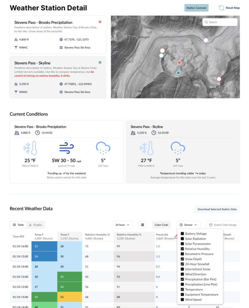
- Weather Station Mockups: Images depicting modernized weather station interfaces suggest a move towards more comprehensive and easily interpretable data displays. This includes visual cues for various weather parameters, potentially offering historical trends and predictive insights at a glance. The inclusion of detailed data points for temperature, wind, and precipitation, presented in a clean, graphical format, will empower users with more informed decision-making capabilities.
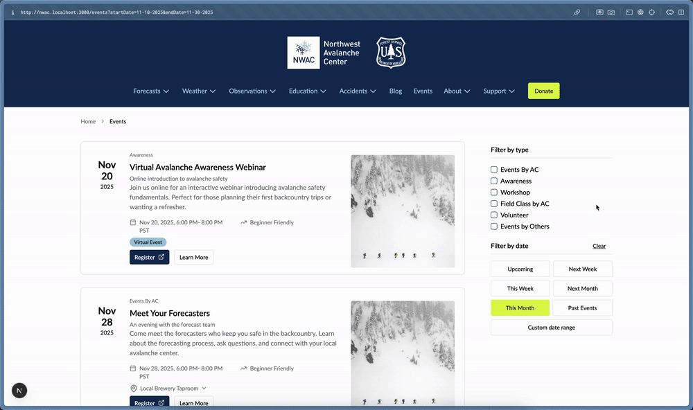
- Event Mockup: A dynamic GIF illustrating event displays indicates an improved system for communicating time-sensitive information. This could encompass alerts for rapidly changing avalanche conditions, planned educational events, or critical safety advisories, ensuring that users are immediately aware of developing situations. The visual representation suggests a clear and immediate communication channel for urgent updates.
- App Mockups: Renderings of the AvyApp interface showcase a sleek and modern design, prioritizing ease of use and accessibility. Features like interactive maps, clear forecast summaries, and streamlined observation reporting tools are evident. The design emphasizes intuitive navigation, allowing users to quickly access the most critical safety information even in challenging field conditions. The visual progression of these mockups highlights a deliberate effort to create a user-friendly and visually appealing application.
The successful implementation of the Avy initiative holds significant promise for enhancing safety and accessibility in North American backcountry environments. By fostering collaboration, leveraging technological advancements, and prioritizing user experience, NWAC and its partner avalanche centers are setting a new standard for avalanche forecasting and mountain safety information, ultimately contributing to a safer and more informed outdoor recreation community.
