
The Climate Prediction Center, a division of the National Oceanic and Atmospheric Administration (NOAA), has officially released its updated seasonal outlook for the core autumn months of October through December 2026. According to the newly published data, much of the United States is favored to experience above-normal temperatures, while distinct regions in the Southwest, southern Plains, and parts of the Southeast stand out for a wet pattern driven heavily by persistent and intensifying climate anomalies in the Pacific Ocean.
Released publicly on September 17, 2026, the updated guidance serves as a critical baseline for industries ranging from agriculture and energy to emergency management and winter recreation. As autumn officially begins and ski resorts across North America prepare for early-season operations, the intersection of warm baseline temperatures and shifting moisture tracks has created a complex outlook for outdoor enthusiasts, climatologists, and regional planners alike.
Comprehensive Temperature Projections: Warmth Favored Nationwide
The headline of NOAA’s October-through-December 2026 temperature probability map is widespread warmth. Above-normal temperatures are favored across vast expanses of the western United States, the northern tier, and virtually the entire region east of the Mississippi River.
The most robust statistical signals—indicating a higher degree of forecast confidence from the Climate Prediction Center—are concentrated over the northern Rockies, the Great Basin, the northern Plains, and the state of Alaska. In these regions, historical climate models combined with current oceanic forcing strongly point toward a milder-than-average end to the calendar year. Similarly, residents and businesses across the Midwest, the Mid-Atlantic, the Northeast, and the Southeast can expect temperatures to tilt above historical climatological norms.
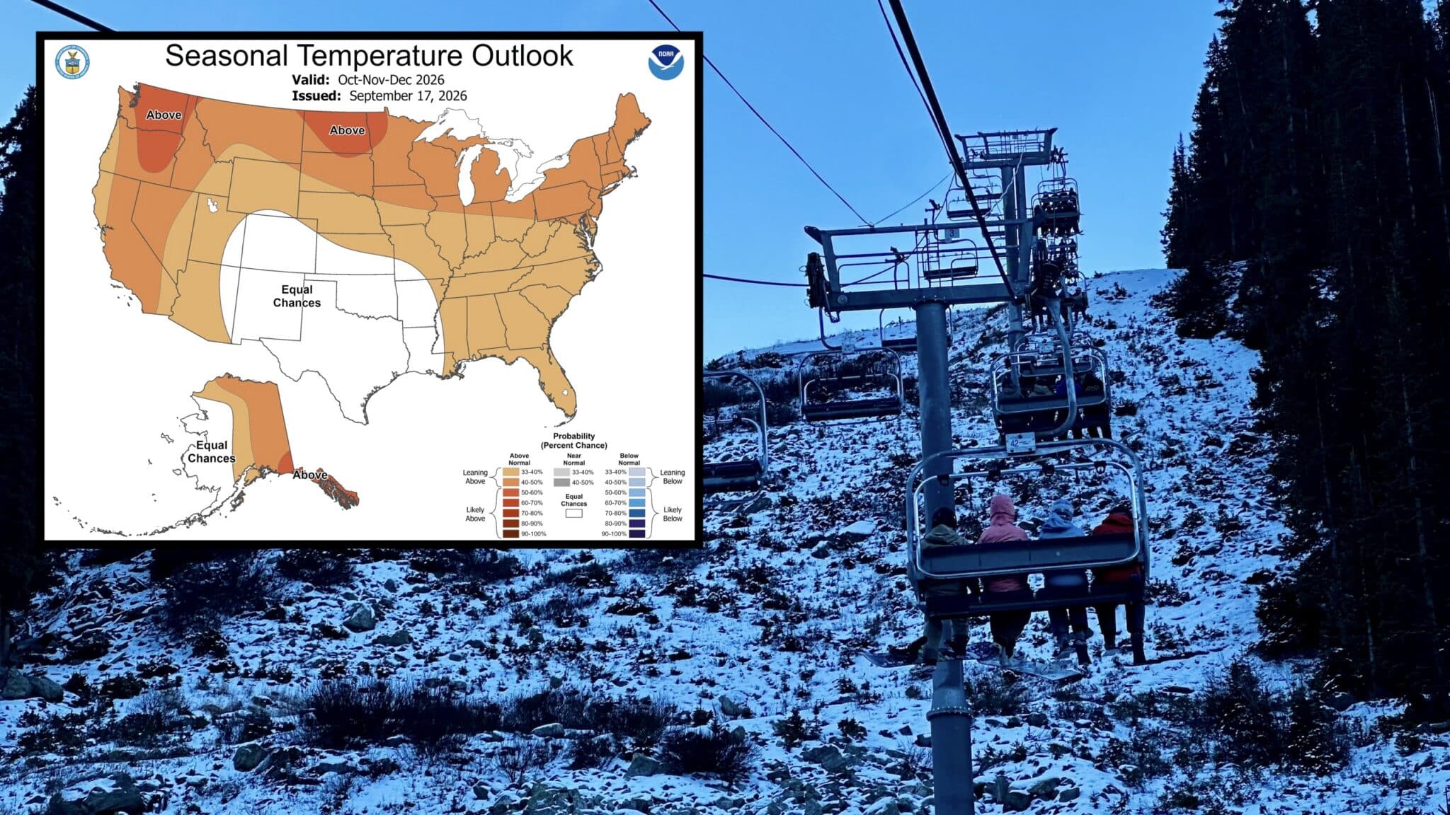
However, the forecast is not uniformly warm across the entire continental United States. A notable zone of uncertainty persists over the southern Rockies and portions of the southern Plains. In these areas, NOAA’s probabilistic models indicate "equal chances" for above-normal, near-normal, or below-normal temperatures. This zone represents a transition region where competing atmospheric drivers make it difficult for long-range forecasters to pin down a definitive thermal trend.
For the winter sports industry, these temperature maps carry immediate implications. Ski resorts that traditionally rely on crisp autumn air to begin snowmaking operations—such as Loveland Ski Area and Arapahoe Basin in Colorado, or Mammoth Mountain in California—may face early-season hurdles if ambient temperatures remain unseasonably high. Nevertheless, climatologists note that high-elevation microclimates can still experience localized sub-freezing nights capable of supporting snowmaking and natural early-season dustings, even during an overall warm autumn.
Precipitation Trends and the Southern Moisture Signal
While temperatures skew warm for a majority of the country, NOAA’s precipitation outlook introduces a distinct geographical split, highlighting a wetter-than-average trend across the southern half of the United States.
The updated models project above-normal precipitation stretching from southern California eastward across the Four Corners region, through the southern Plains, and extending into the Mississippi Valley, the Southeast, and the Mid-Atlantic. This configuration is a classic signature of Pacific moisture being funneled into the southern tier of the country, driven by large-scale atmospheric circulation patterns.
For winter sports enthusiasts monitoring the southwest and southern Rocky Mountain corridors, this wetter signal offers a glimmer of hope. Iconic ski destinations such as Taos Ski Valley in New Mexico, Wolf Creek Ski Area in southern Colorado, and Telluride could see an active parade of storms during the late fall.

Yet, meteorologists caution that precipitation anomalies do not automatically translate to deep powder packs. The crucial variable for high-altitude resorts remains ambient temperature during storm events. Because the broader seasonal outlook favors warmer-than-average temperatures across many western regions, incoming autumn storms will face a delicate threshold. Should low-pressure systems pull in milder air masses, moisture that might typically fall as early-season snow at mid-to-low elevations could instead manifest as rainfall, limiting initial snowpack accumulation until true winter cold establishes itself later in the year.
The El Niño Factor: A Driving Force Behind the 2026 Outlook
At the heart of the Climate Prediction Center’s latest seasonal guidance is the continued evolution and strengthening of El Niño conditions in the equatorial Pacific Ocean.
According to NOAA’s comprehensive monitoring data, the probability of El Niño persisting through the Northern Hemisphere fall and winter seasons currently exceeds 90 percent. Furthermore, the agency’s statistical models indicate an alarming 75 percent chance that this specific El Niño event could reach historic strength during the peak October-through-December window.
El Niño is characterized by warmer-than-average sea surface temperatures across the central and eastern tropical Pacific. These thermal anomalies fundamentally alter atmospheric pressure gradients, jet stream pathways, and global weather patterns. The classic El Niño teleconnection typically features a suppressed northern jet stream and a vigorous, moisture-laden southern sub-tropical jet stream.
This atmospheric setup directly explains the wetter trends projected across the southern tier of the United States in the new NOAA outlook. When the sub-tropical jet stream is active and shifted northward across Mexico and the U.S. southern border, it acts as a conveyor belt for Pacific storms, dumping substantial rain and mountain snow across California, the Southwest, and the Gulf Coast. Conversely, it often starves the Pacific Northwest and northern tier of consistent storm tracks while promoting milder continental air masses.

Implications for Agriculture, Energy, and Winter Recreation
The release of NOAA’s seasonal outlook triggers cascading planning processes across multiple economic and ecological sectors.
In the agricultural sector, unseasonably warm temperatures combined with targeted wet zones require careful management. Farmers harvesting late-season crops in the Midwest and East will monitor soil moisture and temperature anomalies to optimize harvest schedules. Meanwhile, agricultural operations in the southern Plains and Southwest will evaluate the projected wetter conditions for potential drought relief, though excessive precipitation in localized areas could occasionally complicate field work.
The energy sector utilizes these long-lead climate predictions to anticipate utility demand. A warmer fall across major population centers in the East and Midwest typically subdues early heating degree days, reducing residential and commercial demand for natural gas and heating oil during October and November. Conversely, energy grid operators must factor in the potential for localized severe weather and heavy rainfall events in the favored wetter zones across the South and Southeast.
For the winter recreation industry—which contributes billions of dollars annually to the U.S. economy—the September 17th outlook serves as a vital strategic planning tool. Mountain resort operators, gear manufacturers, and tourism boards analyze these probabilistic maps to calibrate snowmaking investments, marketing campaigns, and hiring timelines. While seasonal outlooks cannot predict the exact trajectory, timing, or snow-to-liquid ratio of individual storm systems, they establish the baseline environmental context in which resorts will attempt to open their lifts.
Chronology and Future Outlooks
The publication of the October–December 2026 outlook is part of a continuous, rolling assessment conducted by the Climate Prediction Center. NOAA meteorologists and climatologists analyze real-time oceanic buoy data, atmospheric pressure readings, satellite observations, and complex computer ensemble models on a monthly basis to refine these long-range projections.

The timeline leading up to the upcoming winter season involves several key milestones:
- September 17, 2026: NOAA releases the updated October–December seasonal outlook, highlighting widespread warmth and southern precipitation anomalies.
- October 15, 2026: The Climate Prediction Center is scheduled to issue its next comprehensive seasonal outlook update, incorporating fresh end-of-September oceanic and atmospheric data as the 2026–2027 winter season draws nearer.
- Late October through November 2026: Early-season cold fronts and high-altitude storms begin testing the localized readiness of ski areas across the Rocky Mountains, California, and the Northeast.
- December 2026: The official meteorological start of winter, at which point the intensity and actual phase behavior of the forecasted El Niño event will be fully observable across North America.
As stakeholders across the country digest the latest data from the Climate Prediction Center, all eyes now turn toward the October 15th update. That upcoming report will provide a clearer picture of how the historic El Niño event continues to shape the atmosphere, offering a sharper focus for communities bracing for the transition from autumn warmth to winter weather.

