
The winter of 2024-2025 is shaping up to be a complex meteorological puzzle for the Pacific Northwest, as forecasters analyze the interplay of the El Niño-Southern Oscillation (ENSO) cycle and regional ocean temperatures to predict snowpack accumulation. Last winter’s experience with a weak La Niña, which failed to deliver the deep, mid-winter snowpacks often associated with this cool phase, has provided a crucial lesson: the strength of ENSO and other atmospheric drivers significantly influences snow depth. This upcoming season’s outlook, informed by the latest climate models and historical data, suggests a leaning towards neutral ENSO conditions, a scenario that typically results in near-average snowpack.
Understanding the El Niño-Southern Oscillation (ENSO)
The El Niño-Southern Oscillation (ENSO) is a naturally occurring climate phenomenon characterized by fluctuations in sea surface temperatures (SSTs) across the central and eastern tropical Pacific Ocean. These fluctuations occur in a cycle, with three distinct phases: El Niño (warm phase), La Niña (cool phase), and Neutral (neither distinctly warm nor cool). ENSO is a primary driver of global weather patterns, significantly impacting precipitation, temperature, and storm tracks across vast regions.
The Oceanic Niño Index (ONI) is the principal metric used to monitor and assess ENSO. It is calculated based on the departure of SSTs from the average in the Niño 3.4 region of the Pacific. A sustained ONI of +0.5°C or higher signifies an El Niño event, while a sustained ONI of -0.5°C or lower indicates a La Niña event. Values between these thresholds are considered Neutral conditions.
2024-2025 ENSO Forecast: A Subtle Shift
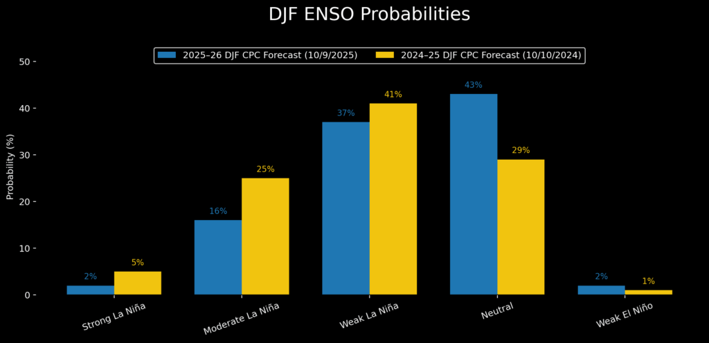
October forecasts for mid-winter ENSO probabilities for the 2024-2025 season show a striking similarity to the previous year’s projections. Both forecasts indicate the highest likelihood of cool-phase conditions (La Niña) during the autumn and early winter months. However, there is a subtle weakening of the La Niña signal for the 2025-2026 period compared to the current outlook.

For the 2024-2025 season, the December-January-February (DJF) ONI in the 2024-25 winter registered -0.6°C, just barely entering the weak La Niña territory. Current weekly SST departures are also hovering around -0.6°C, suggesting a potential recurrence of a weak La Niña. Mid-October Oceanic SST models predict a November minimum ONI of approximately -0.8°C, with values expected to decrease to around -0.3°C by mid-winter (DJF). This projection places neutral ENSO conditions as the most probable outcome for the Pacific Northwest’s mid-winter snowpack.
Historical Snowpack Response to ENSO Phases
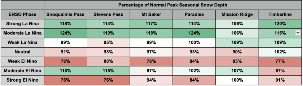
The Pacific Northwest Snowpack Climatology Dataset provides valuable insights into how mountain snowpack typically responds to different ENSO phases. This dataset, analyzed across six representative Cascade weather stations, reveals distinct patterns:
- Weak La Niña: During weak La Niña winters, most stations generally experience snowpack levels near the average. Only specific locations like Mission Ridge and Timberline have historically shown modest gains.
- Moderate and Strong La Niña: These stronger La Niña events have historically favored the western slopes and crest of the Cascade Mountains, leading to peak snow depths ranging from 6% to 24% above normal.
- Neutral ENSO Conditions: Neutral years typically result in snowpack levels slightly below the regional average.
- El Niño: El Niño conditions generally tilt the odds strongly towards reduced snowfall accumulation across the region.
Analyzing the 2024-2025 Outlook: Data and Projections
The DJF forecast distribution for ENSO probabilities for the upcoming winter includes an 18% chance of a moderate to strong La Niña and a 2% chance of El Niño. These "long tails" of the distribution, representing less probable but impactful scenarios, carry significant weight in determining the overall outlook.
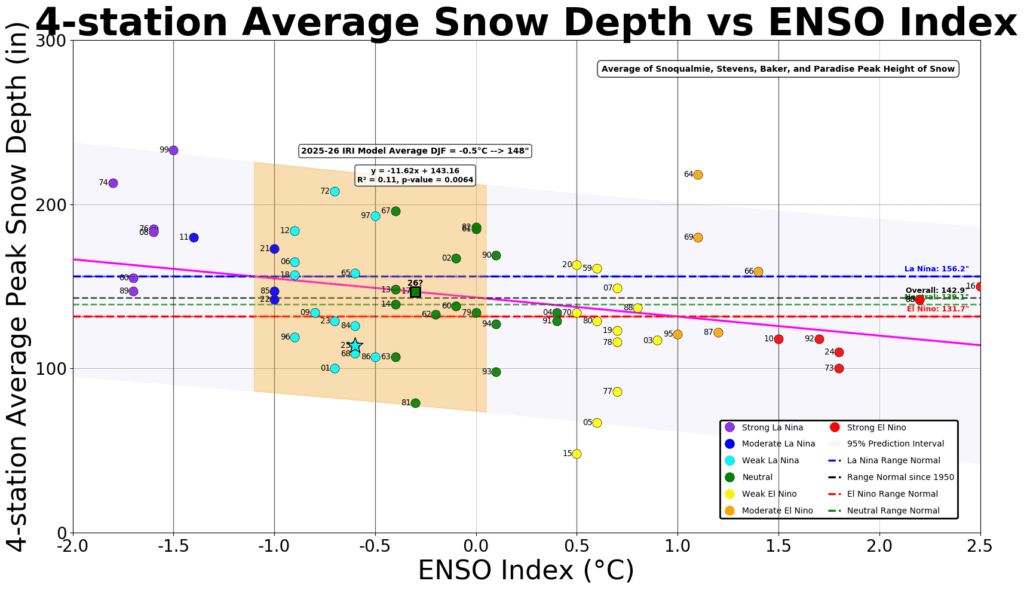
To refine the prediction of the most likely outcomes, an analysis was conducted focusing on the average snowpack data from four stations with the longest and most robust historical records: Mt. Baker, Stevens Pass, Snoqualmie Pass, and Paradise.
In the 2024-25 season, the average peak snow depth was projected to be around the 19th percentile for data within the -1°C to 0°C ENSO Index interval. This figure was 24% below the regression trendline, indicating a potential for reduced snowpack, particularly at lower elevations, influenced by warmer temperatures.
To mitigate the impact of longer-term climate trends, an analysis was performed using only 21st-century data. This truncated dataset showed a general reduction in mean snow depth across all ENSO phases. Even with this adjustment, the ENSO forecast for the 2024-2025 winter pointed towards an "almost perfectly ‘average’" winter in terms of snowpack accumulation.
Linear best-fit trendlines suggest that ENSO alone explains 11% to 19% of the variability in snowpack data, depending on whether 20th-century data is included. This highlights that over 80% of season-to-season variability in snowpack is not directly attributable to ENSO.
The Influence of Pacific Sea Surface Temperatures (SSTs)
The role of regional SSTs, particularly the phenomenon sometimes referred to as "The Blob" in the Pacific Northwest’s nearshore waters, is a critical factor. A comparison of SSTs from September and October in 2025 against 2024 and 2014 revealed that while all these seasons experienced mostly positive anomalies, the deeper color data warrants closer examination.
The 2014-15 season, marked by a very weak El Niño, was characterized by anomalously warm SSTs just off the coast. Scientists have linked these warm waters to a particularly poor snow year, with the 4-station average snowpack readings languishing at less than 50% of the 2024-25 season’s values.
Although September 2025 began with significantly warm SSTs across the Northeast Pacific, these waters have since cooled considerably, with proximal waters approaching normal levels. This cooling trend is a positive indicator for potential snowpack accumulation.
Combining ENSO and Regional SSTs for a More Comprehensive Model
When ENSO phase is considered in conjunction with proximal West Coast Marine waters (SSTs), approximately 25% of the snowpack’s inter-seasonal variability can be explained. This indicates that regional ocean temperatures play a significant role, complementing ENSO’s influence.
The potential for an eastward spread of extraordinarily warm waters in the western North Pacific remains a point of observation. As long as these exceptionally warm waters stay west of Hawaii, the region is likely to remain under the negative phase of the Pacific Decadal Oscillation (PDO). The State Climate Office has noted that a negative PDO phase correlates with cooler, snowier periods in the Pacific Northwest. A similar analysis of PDO versus ENSO phase explains about 20% of the snowpack variance.
Broader Implications and Future Outlook
The current analysis suggests that while a weak La Niña is anticipated, it is likely to transition into neutral ENSO conditions by mid-winter. This scenario portends a fairly typical snowpack for the Pacific Northwest region. The probability of a moderate or strong La Niña remains low, but if such an event were to materialize, it would significantly increase the chances of deeper snow accumulation.
Regional sea surface temperatures have shown a welcome cooling trend, moving closer to normal. However, surrounding warmer waters may limit the potential for further significant cooling, which could otherwise enhance snowpack development.
Ultimately, the snowpack outlook for the winter of 2024-2025 is nuanced. The scientific community acknowledges that no single predictor offers a perfect forecast. With ENSO and regional Sea Surface Temperatures explaining, at best, about 25% of the variability within a 75-year dataset, other factors undoubtedly contribute to the complex mosaic of winter weather.
For optimal snowpack conditions, stakeholders, including winter sports enthusiasts, water resource managers, and local communities, will be closely monitoring several key indicators: sustained upwelling of cooler ocean waters off the coasts of South and North America, the continuation of cool-phase PDO conditions, and the health of marine ecosystems, symbolized by the abundance of sardines and salmon. These interconnected factors collectively influence the atmospheric patterns that will ultimately dictate the depth and duration of the winter snowpack across the Pacific Northwest.
Disclaimers:
This analysis is based on current climate models and historical data. Weather patterns are inherently complex and subject to change. Unexpected atmospheric events or shifts in oceanic conditions could alter the projected snowpack accumulation. Readers are advised to consult updated forecasts from official meteorological agencies for the most current information.

