
The National Oceanic and Atmospheric Administration (NOAA) has released its initial Winter Weather Prediction for 2027, providing forecasters and the public with an early outlook on the anticipated temperature and precipitation patterns across the United States for the critical January through March period. This long-range forecast, issued by the NOAA Climate Prediction Center (CPC), signals the potential emergence of a well-defined El Niño pattern, suggesting a winter that could bring wetter conditions to much of the southern United States, drier weather to portions of the northern Rockies, and a higher probability of above-normal temperatures across extensive areas of the nation.
It is crucial to understand that these broad seasonal outlooks do not predict the exact timing, intensity, or accumulation of snowfall for individual winter storms. Instead, they serve as valuable indicators of prevailing atmospheric conditions, highlighting regions where storm tracks are statistically more likely to favor wetter, drier, warmer, or cooler weather during the winter of 2026-2027. This early insight is particularly important for sectors such as agriculture, water management, energy planning, and the winter recreation industry.
Forecasting the Heart of Winter: January-March 2027
The NOAA Climate Prediction Center’s outlook specifically encompasses the three-month period from January to March 2027, often abbreviated in meteorological circles as JFM. While this period represents the core of the winter season, it is important to note that it does not include December 2026. NOAA routinely issues overlapping three-month forecasts throughout the year, such as November-January and December-February, allowing for continuous monitoring and refinement of seasonal predictions. The January-March timeframe is especially significant for winter sports enthusiasts, as it typically coincides with the period when snowpack depth reaches its maximum in many mountainous regions.
The initial forecast was released on July 16, 2026, and NOAA indicates that this outlook will undergo monthly updates as the winter season approaches, providing increasingly refined predictions. This proactive release allows stakeholders ample time to prepare for potential weather-related impacts.
The Dominant Influence: A Strengthening El Niño
A pivotal factor shaping the Winter Weather Prediction for 2027 is the anticipated strengthening of an El Niño event. According to NOAA’s latest ENSO (El Niño-Southern Oscillation) Diagnostic Discussion, El Niño conditions are expected to intensify through the remainder of 2026, with a remarkable 97% probability of persisting into early spring 2027. Furthermore, the developing El Niño has an 81% chance of reaching "very strong" intensity between October and December 2026.
El Niño is a naturally occurring climate pattern characterized by warmer-than-average sea surface temperatures in the central and eastern tropical Pacific Ocean. This oceanic warming significantly influences global atmospheric circulation, often leading to shifts in the position of the jet stream across North America. During robust El Niño winters, the Pacific storm track typically migrates southward. This southward shift commonly results in increased precipitation along the West Coast, extending into the Southwest, southern Rockies, southern Plains, and the Southeast. Conversely, regions in the Pacific Northwest and northern Rockies may experience drier and warmer conditions.
While historical data provides a general framework for El Niño impacts, each event is unique. Therefore, the predicted El Niño pattern does not guarantee above-average snowfall for any specific ski resort or location. The interplay of various atmospheric factors creates a complex weather system.
NOAA’s Temperature Outlook: January-March 2027
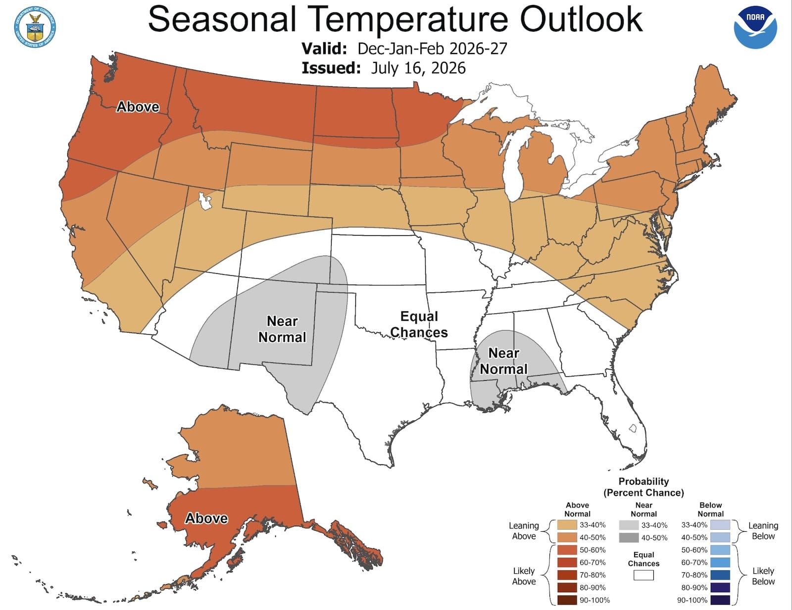
The temperature outlook for January through March 2027, as depicted in NOAA’s forecast maps, favors above-normal temperatures across a substantial portion of the United States. This includes much of the Western United States, the northern tier of states, the East Coast, and Alaska. The strongest signals for warmer-than-average conditions are concentrated in the West, the northern regions of the country, the Eastern Seaboard, and Alaska.
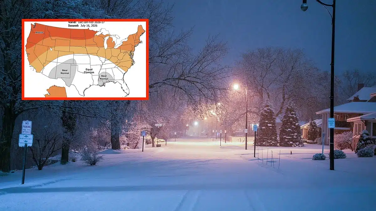
In certain areas of the central and southern interior United States, the confidence in temperature predictions is lower, with equal probabilities assigned for above-normal, near-normal, or below-normal temperatures. This zone of uncertainty highlights the complex atmospheric dynamics at play.
It is essential to interpret "above normal" in the context of seasonal averages. This prediction does not imply that every day will be unseasonably warm. A region can still experience significant Arctic outbreaks, severe cold snaps, and extended periods of sub-freezing temperatures and still conclude the three-month period with an above-average overall temperature.
Implications of the Temperature Forecast for Winter Recreation
The projected warmer temperatures raise concerns for lower-elevation ski resorts, particularly in regions like Washington, Oregon, coastal British Columbia, and the Northeastern United States. Warmer atmospheric conditions during storm events can lead to an increased likelihood of rain or mixed precipitation at lower elevations, potentially impacting snow quality and snowpack stability.
Conversely, higher-elevation ski resorts are generally better positioned to benefit from increased moisture, even in a warmer winter. Destinations such as Mammoth Mountain in California, Snowbird in Utah, and the highest ski areas in Colorado may still experience substantial snowfall due to their altitude, which favors colder temperatures for snow accumulation.
For the Eastern United States, a warmer seasonal outlook does not preclude the possibility of significant snowstorms. However, the increased likelihood of thaws or mixed precipitation events could interrupt otherwise favorable periods for snow accumulation, leading to more variable snow conditions.
NOAA’s Precipitation Outlook: January-March 2027
The precipitation outlook for January through March 2027 reveals a pattern that more strongly aligns with a classic El Niño signature. NOAA anticipates above-normal precipitation across a broad swath of the southern United States. This wetter trend is expected to commence in Southern California and the Southwest, extending eastward through Texas, along the Gulf Coast, across the Southeast, and into portions of the eastern United States. The highest probabilities for above-normal precipitation are notably concentrated over parts of the Southeast.
In contrast, below-normal precipitation is favored across the Pacific Northwest, the northern Rockies, and the northern Plains. Significant geographical areas situated between these wetter southern and drier northern patterns are designated as having "equal chances" of precipitation, indicating a higher degree of uncertainty in those regions.
Regional Precipitation Forecasts and Potential Impacts
-
Southern California and the Sierra Nevada: Southern California is clearly situated within the projected zone of above-normal precipitation. This wet signal extends towards parts of the Sierra Nevada and the Great Basin. This outlook could be encouraging for California’s ski resorts, especially those at higher elevations. A robust southern storm track associated with El Niño can frequently deliver significant Pacific storm systems and atmospheric rivers into the state. However, a key concern remains temperature. A warm atmospheric river, while delivering substantial precipitation, could result in rain or heavy, dense snow at lower elevations. The highest elevations of the Sierra Nevada would possess the greatest likelihood of converting this moisture into substantial snowfall.
-
Arizona and New Mexico: These states emerge as potentially promising regions in the Winter Weather Prediction 2027. NOAA favors above-normal precipitation across both Arizona and New Mexico, consistent with the typical southern storm track dynamics during El Niño events. This could prove beneficial for high-elevation ski areas such as Arizona Snowbowl, Taos Ski Valley, Ski Santa Fe, and Angel Fire. While these regions can experience extended dry spells, the prospect of multiple moisture-rich storm cycles could significantly enhance the overall ski season.
-
Utah and Colorado: The projected wetter southern pattern extends towards portions of Utah and Colorado, with southern areas generally appearing more favorable than their northern counterparts. Colorado’s San Juan Mountains, in particular, could experience advantageous conditions if storms consistently traverse the Four Corners region. Resorts such as Wolf Creek, Telluride, Silverton, and Purgatory would likely benefit from such a storm trajectory. Northern Colorado and northern Utah lie closer to the transitional zone between NOAA’s predicted wet and dry signals, making their winter weather patterns more dependent on the precise positioning of the Pacific jet stream.
-
Pacific Northwest and Northern Rockies: The outlook presents less optimistic prospects for parts of Washington, Oregon, Idaho, Montana, and Wyoming. NOAA favors below-normal precipitation across sections of the Pacific Northwest, northern Rockies, and northern Plains. Much of this region also faces an increased probability of above-normal temperatures. This combination could translate to fewer sustained storm cycles and higher snow levels, particularly impacting lower-elevation ski areas. It is important to emphasize that this forecast does not predict a snowless winter for these regions. Resorts like Mount Baker, Crystal Mountain, Jackson Hole, Grand Targhee, Big Sky, and Whitefish are still capable of experiencing significant powder events. The primary concern is that productive storm cycles might become less frequent or be separated by longer periods of dry and mild weather.
-
Great Lakes and Northeast: The precipitation outlook for the Great Lakes and Northeast regions is more complex. Parts of the Great Lakes area are situated near NOAA’s drier northern signal, while the Mid-Atlantic and other areas of the eastern United States are closer to the wetter southern storm track. Above-normal temperatures are favored across much of the East. This could lead to an increased frequency of rain or mixed precipitation at lower elevations, but it does not preclude the occurrence of major snowstorms. A strong southern jet stream can deliver ample moisture for East Coast storms. If sufficient cold air is present, this moisture can coalesce to produce significant Nor’easters. In the absence of sustained cold temperatures, the same storm track might result in coastal rain and snow further inland or at higher elevations.
Understanding Precipitation vs. Snowfall
A critical distinction to be made is that NOAA’s seasonal precipitation map measures total rainfall and the melted equivalent of snow. It does not directly predict the proportion of precipitation that will fall as snow. Therefore, a region experiencing above-normal precipitation could still have a disappointing snowfall season if storms are consistently too warm, resulting in rain. Conversely, a region with near-normal precipitation might enjoy an excellent ski season if the majority of that moisture arrives in the form of cold, dry snow.
The most significant factors influencing snowfall accumulation at individual ski resorts include:
- Temperature during precipitation events: Colder temperatures are essential for snow.
- Elevation of the ski area: Higher elevations are more likely to remain below freezing.
- Storm track trajectory: The path of storms dictates the type of air mass and moisture they carry.
- Moisture content of incoming systems: The amount of water vapor available in the atmosphere.
For these reasons, NOAA’s outlook should be interpreted as a broad guide to potential weather patterns rather than a definitive resort-level snow forecast.
Winter Weather Prediction 2027: Regional Summary
Most Favorable Precipitation Signal:
- Southern California
- Southwest (Arizona, New Mexico)
- Southern Rockies (Southern Colorado, Utah)
- Texas
- Gulf Coast
- Southeast
- Parts of the Eastern United States
Regions Facing a Drier Signal:
- Pacific Northwest (Washington, Oregon)
- Northern Rockies (Idaho, Montana, Wyoming)
- Northern Plains
Biggest Concern:
Above-normal temperatures across many regions could lead to higher snow levels and an increased likelihood of rain at lower-elevation ski areas, impacting snow quality and consistency.
Biggest Opportunity:
High-elevation mountain ranges in California, the Southwest, and southern Colorado could benefit significantly from an active southern storm track, potentially leading to favorable snow conditions despite broader warming trends.
Anticipating the 2026-2027 Winter Season
The question of whether the winter of 2026-2027 will be snowy depends heavily on regional factors. NOAA’s outlook suggests a higher probability of wetter conditions across the southern tier of the United States, encompassing areas from Southern California eastward to the Southeast. The crucial determinant for snowfall in these regions will be the prevailing temperatures and the elevation of the land.
For California, the outlook presents meaningful potential, particularly for higher-elevation ski destinations. Southern California and other parts of the state fall within NOAA’s predicted wetter pattern. However, the possibility of warm atmospheric rivers and subsequent high snow levels remains a consideration.
The influence of El Niño on the 2026-2027 winter is expected to be substantial. NOAA’s forecast of a strengthening El Niño event that will persist into early spring 2027 underscores its role as a primary driver of winter storm tracks across North America.
Ski regions that may face challenges include parts of the Pacific Northwest and the northern Rockies, where a combination of warmer temperatures and below-normal precipitation is anticipated. Lower-elevation ski areas within these regions could be particularly vulnerable to rain and inconsistent snowpack development.
NOAA’s seasonal forecasts are designed to predict broad trends over several months and cannot reliably forecast individual snowstorms this far in advance. Detailed storm-specific predictions typically become feasible only much closer to the event’s anticipated arrival.
The Bottom Line
NOAA’s Winter Weather Prediction 2027 strongly indicates a winter season heavily influenced by an emerging El Niño pattern. The most promising precipitation signals are concentrated across the southern United States, including California, the Southwest, the southern Rockies, Texas, and the Southeast. Conversely, the Pacific Northwest and northern Rockies face an increased likelihood of below-normal precipitation.
For skiers and snowboarders, this forecast presents a duality of opportunity and potential challenges. High-elevation resorts in California, the Southwest, and southern Colorado could experience favorable conditions due to an active southern storm track. However, lower-elevation mountains and ski areas in the northern United States might contend with warmer temperatures, elevated snow levels, and potentially prolonged dry spells.
This initial outlook serves as a preliminary guide. NOAA will continue to issue monthly updates to its seasonal maps, allowing for greater clarity and detail as the 2026-2027 winter season draws nearer. Stakeholders are advised to monitor these updates for the most current and refined predictions.
Sources: NOAA Climate Prediction Center Seasonal Outlooks and NOAA Long-Lead Seasonal Forecast Discussion.

